Mount Shasta Area | Lassen Area | Trinity Alps | Shasta-Trinity NF | Klamath NF | Redwood Coast | Wine Country | Bay Area | Sierra Nevada | Hiking Advice
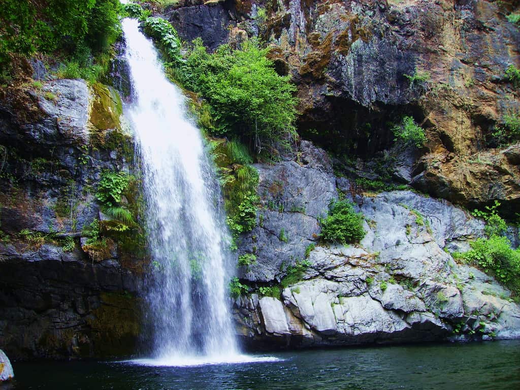
Potem Creek tumbles 70 feet over Potem Falls to crash into a beautiful, rock-rimmed swimming hole, all yours for a short trail hike.
Potem Falls, near the Pit River in the Shasta Lake National Recreation Area of Shasta-Trinity National Forest, is one of the most beautiful waterfalls in northern part of Northern California. Unlike Burney Falls and the three waterfalls of the McCloud River near Highway 89, Potem Falls is a bit off the beaten track, which means you’ll share it with relatively few people.
Potem Falls on Potem Creek. (rcrundwell via Creative Commons license)
Potem Falls Trail Key Data
Distance: 0.6 mile round-trip
Difficulty: Easy
Type: Day hike
Elevation gain: 140 feet
High point: 1300 feet
Season: year-round
Information: Shasta Lake Ranger Station, Shasta Lake National Recreation Area, Shasta-Trinity National Forest; 530-275-1587; website here
Permits: no permit needed
Potem Falls Trailhead GPS coordinates: N 40 50.332 W 122 01.610
Notes: dogs allowed on leash
Potem Falls: When to Visit
Potem Creek flows strongest in winter and spring, especially after rainstorms, so go then if you want to see Potem Falls in full glory. However, late spring through early fall is the best time to swim, since air temperatures are highest and the pool at the base of the waterfall is so inviting. The hottest days are in July and August.
Potem Falls Trailhead Directions
From Redding, take Exit 680 off Interstate 5 onto CA Highway 299. Drive 30.5 miles and then turn left onto Fenders Ferry Road, which is also known as Forest Road 34N17 and Road 27. It’s paved for the first 3.5 miles and then good dirt thereafter. Cross the Pit River on a bridge at 8.8 miles. Watch carefully for the unsigned trailhead on the left 0.6 mile beyond the bridge, a total of 9.4 miles from Highway 299. You can usually hear the waterfall from the trailhead.
Potem Falls hiking trail map: Shasta-Trinity National Forest near Shasta Lake National Recreation Area. Includes Pit River and Fenders Flat. (Courtesy of Caltopo.com)
Hiking the Potem Falls Trail
The trail descends moderately for 0.3 mile through a forest of canyon live oak, Douglas fir, and ponderosa pine. Look for a view down at Potem Falls at the first switchback. Two more switchbacks bring you to the base of the waterfall.
Potem Falls plunges to a cacophonous meeting with a deep and broad pool, creating a cooling mist that feels great on hot days. Come from late morning to mid-afternoon if you want sun; otherwise the steep walls of the Potem Creek drainage create full shade.
More Shasta Lake Hiking Trails
I’m the author of several Northern California hiking guidebooks. My book Day Hiking: Mount Shasta, Lassen & Trinity Alps Regions has 125 hikes, including four trails/trail systems in Shasta Lake National Recreation Area:
Dry Creek Trail from Shasta Dam
Waters Gulch Trails (including Overlook Trail, Fish Loop Trail, and Eastside Trail)
Bailey Cove Trail
Hirz Bay Trail
The book also covers 15 hikes in and around Redding, 11 hikes in Whiskeytown National Recreation Area, and six hikes to the north in Castle Crags State Park.
I don’t think you can easily hike directly to it from the lake, but I’ve never tried. I searched a bit online and found info about leaving your boat near the Pit River dam, walking up to Fender’s Ferry Road, and then walking on the road to the trail.
Like just about every other website on the planet, NCHT uses cookies. Continuing to use the site means you're OK with that.Cookie settingsACCEPT
Privacy & Cookies Policy
Privacy Overview
This website uses cookies to improve your experience while you navigate through the website. Out of these cookies, the cookies that are categorized as necessary are stored on your browser as they are essential for the working of basic functionalities of the website. We also use third-party cookies that help us analyze and understand how you use this website. These cookies will be stored in your browser only with your consent. You also have the option to opt-out of these cookies. But opting out of some of these cookies may have an effect on your browsing experience.
Necessary cookies are absolutely essential for the website to function properly. This category only includes cookies that ensures basic functionalities and security features of the website. These cookies do not store any personal information.
Any cookies that may not be particularly necessary for the website to function and is used specifically to collect user personal data via analytics, ads, other embedded contents are termed as non-necessary cookies. It is mandatory to procure user consent prior to running these cookies on your website.


 I’m the author of several Northern California hiking guidebooks. My book Day Hiking: Mount Shasta, Lassen & Trinity Alps Regions has 125 hikes, including four trails/trail systems in Shasta Lake National Recreation Area:
 Getting to the trailhead
%27%20fill-opacity%3D%27.5%27%3E%3Cellipse%20fill%3D%22%239c98b2%22%20fill-opacity%3D%22.5%22%20rx%3D%221%22%20ry%3D%221%22%20transform%3D%22matrix(65.36121%20-280.87309%2052.18426%2012.14366%20142.5%20122.7)%22%2F%3E%3Cellipse%20fill%3D%22%231d1c23%22%20fill-opacity%3D%22.5%22%20rx%3D%221%22%20ry%3D%221%22%20transform%3D%22rotate(-64.2%20109%2052.9)%20scale(104.18013%2052.12935)%22%2F%3E%3Cellipse%20fill%3D%22%23596c00%22%20fill-opacity%3D%22.5%22%20rx%3D%221%22%20ry%3D%221%22%20transform%3D%22matrix(-47.08369%2099.12165%20-38.27896%20-18.18285%20269%20109)%22%2F%3E%3Cellipse%20fill%3D%22%239e95c9%22%20fill-opacity%3D%22.5%22%20rx%3D%221%22%20ry%3D%221%22%20transform%3D%22matrix(26.30612%2067.4717%20-23.70779%209.24328%20123.6%20183)%22%2F%3E%3C%2Fg%3E%3C%2Fsvg%3E "Hike Faery Falls: Fantastic Waterfall on Ney Springs Creek Near Mount Shasta")
%22%20transform%3D%22translate(.6%20.6)%20scale(1.17188)%22%20fill-opacity%3D%22.5%22%3E%3Cellipse%20fill%3D%22%2345563b%22%20rx%3D%221%22%20ry%3D%221%22%20transform%3D%22matrix(10.99763%2038.60747%20-128.34326%2036.55954%2052.5%20122.5)%22%2F%3E%3Cellipse%20fill%3D%22%234199e6%22%20rx%3D%221%22%20ry%3D%221%22%20transform%3D%22matrix(-207.05174%203.54946%20-.91932%20-53.6268%20126.8%2028.1)%22%2F%3E%3Cellipse%20fill%3D%22%23be9b8b%22%20rx%3D%221%22%20ry%3D%221%22%20transform%3D%22matrix(115.9203%20-27.06319%2010.21514%2043.75472%20182.2%20143.5)%22%2F%3E%3Cellipse%20fill%3D%22%232e656d%22%20cx%3D%22164%22%20cy%3D%2281%22%20rx%3D%2255%22%20ry%3D%2228%22%2F%3E%3C%2Fg%3E%3C%2Fsvg%3E "Hike Black Butte Trail: Summit Vista of Mount Shasta!")
%27%20fill-opacity%3D%27.5%27%3E%3Cellipse%20fill%3D%22%239b9b9b%22%20fill-opacity%3D%22.5%22%20rx%3D%221%22%20ry%3D%221%22%20transform%3D%22matrix(16.7135%20100.95812%20-81.84792%2013.54984%20170.8%20105.5)%22%2F%3E%3Cellipse%20fill%3D%22%232b2b2b%22%20fill-opacity%3D%22.5%22%20rx%3D%221%22%20ry%3D%221%22%20transform%3D%22rotate(-94.7%2038.6%2036.2)%20scale(123.63728%2060.67354)%22%2F%3E%3Cellipse%20fill%3D%22%23191919%22%20fill-opacity%3D%22.5%22%20rx%3D%221%22%20ry%3D%221%22%20transform%3D%22matrix(-38.44359%20-10.8993%205.8843%20-20.75483%20276.3%209.6)%22%2F%3E%3Cellipse%20fill%3D%22%23b5b5b5%22%20fill-opacity%3D%22.5%22%20rx%3D%221%22%20ry%3D%221%22%20transform%3D%22matrix(20.06966%20-16.64785%2030.72656%2037.04211%20146.2%20135.3)%22%2F%3E%3C%2Fg%3E%3C%2Fsvg%3E "Hike Beautiful Burney Falls Trails in 2026")
%22%20transform%3D%22translate(.6%20.6)%20scale(1.17188)%22%20fill-opacity%3D%22.5%22%3E%3Cellipse%20rx%3D%221%22%20ry%3D%221%22%20transform%3D%22matrix(71.29407%2020.37065%20-13.25093%2046.37618%20208.6%20149)%22%2F%3E%3Cellipse%20fill%3D%22%23838284%22%20rx%3D%221%22%20ry%3D%221%22%20transform%3D%22rotate(137.9%2036.7%2026.3)%20scale(52.00329%2074.51482)%22%2F%3E%3Cpath%20fill%3D%22%23909479%22%20d%3D%22M-9.3%20146.5l123.8-17.4%208.8%2062.4L-.5%20208.9z%22%2F%3E%3Cellipse%20fill%3D%22%23828183%22%20cx%3D%22240%22%20cy%3D%2211%22%20rx%3D%2249%22%20ry%3D%2264%22%2F%3E%3C%2Fg%3E%3C%2Fsvg%3E "Hedge Creek Falls Trail: Easy Hike Beside I-5")
%27%20fill-opacity%3D%27.5%27%3E%3Cellipse%20fill%3D%22%23f9f4ff%22%20fill-opacity%3D%22.5%22%20rx%3D%221%22%20ry%3D%221%22%20transform%3D%22matrix(91.31382%2066.02258%20-35.05562%2048.48435%2046.5%20157.6)%22%2F%3E%3Cpath%20fill%3D%22%23b8c768%22%20fill-opacity%3D%22.5%22%20d%3D%22M238.3%20231.9L140-24.1l129.1-49.6%2098.3%20256z%22%2F%3E%3Cellipse%20fill%3D%22%23b4aece%22%20fill-opacity%3D%22.5%22%20rx%3D%221%22%20ry%3D%221%22%20transform%3D%22rotate(-113.2%20136.3%2016.5)%20scale(262.7941%2029.81633)%22%2F%3E%3Cellipse%20fill%3D%22%23d3e187%22%20fill-opacity%3D%22.5%22%20rx%3D%221%22%20ry%3D%221%22%20transform%3D%22rotate(49%20-28.4%2084)%20scale(111.55642%2038.65434)%22%2F%3E%3C%2Fg%3E%3C%2Fsvg%3E "Burney Falls January 2025 Hiking Trails Closure Details")


Hi! I was wondering if you can get to Potem Falls by boat via Shasta Lake?
I don’t think you can easily hike directly to it from the lake, but I’ve never tried. I searched a bit online and found info about leaving your boat near the Pit River dam, walking up to Fender’s Ferry Road, and then walking on the road to the trail.