Mount Shasta Area | Lassen Area | Trinity Alps | Shasta-Trinity NF | Klamath NF | Redwood Coast | Wine Country | Bay Area | Sierra Nevada | Hiking Advice
The Black Butte Trail climbs steeply up volcanic Black Butte just west of Mount Shasta in Siskiyou County. It’s a day hike that will give you a good workout, and it features stunning views of Mount Shasta, Mount Eddy, Castle Crags, and the Trinity Divide Mountains. Full trail description and trail map below…
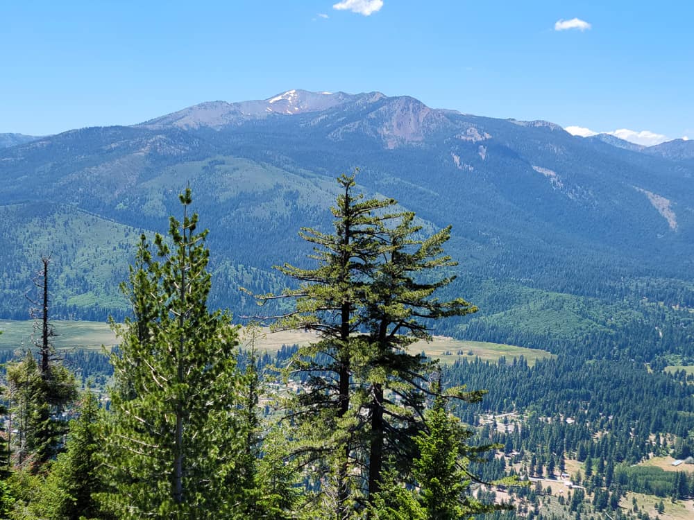
Black Butte viewed from near Everitt Memorial Highway on the west slope of Mount Shasta
Black Butte was practically in my backyard when I lived in Siskiyou County: I was within 10 crow miles of it for many years. I love to climb it. It’s one of the first real hikes I do in late spring as soon as the snow melts off the north side. (And, according to long-time Mount Shasta locals, that’s when you should plant your garden.)
The trail to Black Butte’s summit is an excellent hike any time there’s no snow or it’s not too hot. Call the Mount Shasta Ranger Station at 530-926-4511 for the current trail conditions.
Length: 5.6 miles round-trip
Hiking time: 4 hours
High point: 6,358 feet
Total elevation gain: 1,850 feet
Difficulty: moderate to strenuous; long stretches of loose talus
Season: mid-May through mid-November
Water: none; bring plenty
USGS Map: USGS 7.5′ City of Mount Shasta
Black Butte Trailhead GPS coordinates: N 41 22.371 W 122 20.423
Information: Mount Shasta Ranger Station, Shasta-Trinity National Forest
Map of the hiking trail to the summit of Black Butte. (Courtesy of Caltopo.com)
To those traveling Interstate 5 in far Northern California, Black Butte looms as a dark, impossibly steep visage rising 2,400 feet right beside the freeway. Surprisingly, a moderately graded hiking trail can take you to the summit of this young volcano, where spectacular views await.
Directions to the Black Butte Trailhead, updated in 2022
Take the Central Mount Shasta exit off I-5, head east through town for 0.7 mile on Lake Street, and curve left onto Everitt Memorial Highway. Drive 2.2 miles and turn left opposite the sign for Spring Hill Plantation onto Forest Road 41N18, an improved road surfaced with recycled asphalt grindings that is easily passable by sedans and other vehicles with relatively low clearance.
Stay on Forest Road 41N18, which is always the best road, as you pass numerous lesser side roads. Occasional signs for the Black Butte trailhead help guide you.
Turn right after 0.1 mile, drive 1.0 mile, and swing 90 degrees left to head straight for Black Butte. Go right (north) at a road fork 0.3 mile farther. After another 1.2 miles, turn left at a powerline undercrossing and continue the final 0.7 mile on a gravel and dirt road (Forest Road41N18A) to the trailhead, which is a small turnaround in the road (a total of 3.2 miles from Everitt Memorial Highway).
Trailhead GPS coordinates: N 41 22.371 W 122 20.423
Hiking the Black Butte Trail
The path initially travels through a forest of Douglas fir, white fir, incense cedar, and ponderosa pine. Common trailside shrubs include bush chinquapin, huckleberry oak, and tobacco brush. As you continue the steady climb across talus slopes, the first of several sweeping vistas opens up to the north, where you’ll see Shasta Valley and the town of Weed directly below and southern Oregon’s Mount McLoughlin, a Cascade sibling of Mount Shasta. At 1.1 miles the path swings southwest, allowing views of Mount Eddy and the Klamath Mountains to the west and Castle Dome and the rest of Castle Crags to the south.
At 1.6 miles the trail heads east, offering you the entrancing image of Mount Shasta, and eventually swings southeast past western white pine, mountain hemlock, and red fir.
Note: along this stretch you’ll briefly pass directly under a sagging wire-retaining wall. Walk quickly past it, as it could potentially give way.
This area is also a good spot to search the far southeast horizon for Magee Peak and Lassen Peak, which lie near the Cascades’ southern boundary.
Best Day Hiking Trails in Upper California
Mycompact guidebook has the 125 best day hikes:
Mount Shasta and nearby
Lassen Volcanic National Park
Trinity Alps and Marble Mountains
Redding area
Whiskeytown and Shasta Lakes
Includes trailhead directions and detailed maps and trail descriptions
Buy it:on Amazon | on Bookshop.org Often available at bookstoresand outdoor stores (call first!)
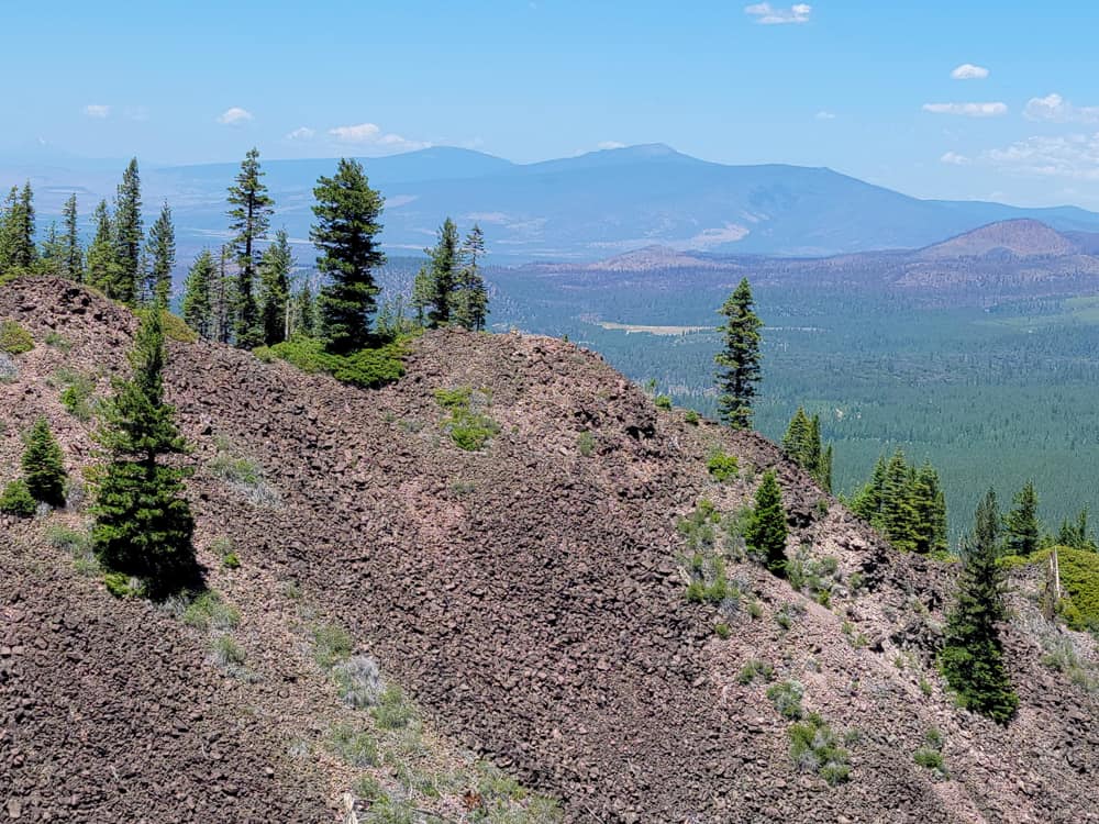
Black Butte’s Summit: View of Mount Shasta!
Climb northwest and then southeast again before switchbacking up the last stretch to Black Butte’s summit at 2.8 miles. Be careful near and at the summit, which has steep drop-offs: watch your footing and be especially wary if it’s windy.
All the previously encountered views come together in a 360-degree panorama. Mount Shasta will certainly demand most of your attention. This majestic peak, elevation 14,179 feet, is a stratovolcano formed by massive eruptions that began about one million years ago. Black Butte, a plug dome, formed from thick pasty lava extruded in four different eruptions about ten thousand years ago, making it quite young by geological standards.
Mount Shasta from the summit of Black Butte on a late spring day
This Trail Map Covers Black Butte and Other Classic Mount Shasta Area Hikes
Comprehensive Trail Map for the Greater Mount Shasta Region
This map is perfect for exploring Mount Shasta and the nearby areas of natural beauty:
Hiking and biking trails on Mount Shasta
Lake Siskiyou and nearby trails
Mount Eddy/Deadfall Lakes trails
Trinity Divide trails, including Castle and Heart Lakes
Castle Crags State Park trails
Pacific Crest Trail
Climbing routes to Mount Shasta’s stunning summit
Designed for hikers, mountain bikers, and equestrians
Often available at outdoor stores and bookstores (call first!)
My Youtube Video of 2022 Black Butte Hike
It’s from my Northern California Hiking Trails Youtube channel.
Pictures from my 2022 Black Butte Climb
Early on the Black Butte Trail begins the first of many sections bordered by talus.Mount Shasta from the lower slopes of Black ButteMount Eddy vista from the west side of the Black Butte TrailThe trail passes through an extensive section of talus. Watch your step!Talus slope on Black ButteMount Shasta from Black Butte SummitMount Shasta from Black Butte Summit
Like just about every other website on the planet, NCHT uses cookies. Continuing to use the site means you're OK with that.Cookie settingsACCEPT
Privacy & Cookies Policy
Privacy Overview
This website uses cookies to improve your experience while you navigate through the website. Out of these cookies, the cookies that are categorized as necessary are stored on your browser as they are essential for the working of basic functionalities of the website. We also use third-party cookies that help us analyze and understand how you use this website. These cookies will be stored in your browser only with your consent. You also have the option to opt-out of these cookies. But opting out of some of these cookies may have an effect on your browsing experience.
Necessary cookies are absolutely essential for the website to function properly. This category only includes cookies that ensures basic functionalities and security features of the website. These cookies do not store any personal information.
Any cookies that may not be particularly necessary for the website to function and is used specifically to collect user personal data via analytics, ads, other embedded contents are termed as non-necessary cookies. It is mandatory to procure user consent prior to running these cookies on your website.


 My compact guidebook has the 125 best day hikes:


%22%20transform%3D%22translate(.6%20.6)%20scale(1.17188)%22%20fill-opacity%3D%22.5%22%3E%3Cellipse%20fill%3D%22%23e2d5bf%22%20rx%3D%221%22%20ry%3D%221%22%20transform%3D%22rotate(-155%20112%2050)%20scale(117.46636%2046.71765)%22%2F%3E%3Cellipse%20fill%3D%22%23004cc3%22%20rx%3D%221%22%20ry%3D%221%22%20transform%3D%22matrix(252.06102%20-13.65114%201.97334%2036.43674%20139.2%209.9)%22%2F%3E%3Cellipse%20fill%3D%22%23261d19%22%20rx%3D%221%22%20ry%3D%221%22%20transform%3D%22matrix(-42.68706%2017.85638%20-11.82445%20-28.26725%20231.4%2055.8)%22%2F%3E%3Cellipse%20fill%3D%22%233674e2%22%20cx%3D%229%22%20cy%3D%2212%22%20rx%3D%2265%22%20ry%3D%2265%22%2F%3E%3C%2Fg%3E%3C%2Fsvg%3E "2024 Free Entrance Days at Northern California National Parks and Monuments")

%22%20transform%3D%22translate(.6%20.6)%20scale(1.17188)%22%20fill-opacity%3D%22.5%22%3E%3Cellipse%20fill%3D%22%23316256%22%20cx%3D%22235%22%20cy%3D%2248%22%20rx%3D%2256%22%20ry%3D%2268%22%2F%3E%3Cellipse%20fill%3D%22%23e1dee4%22%20rx%3D%221%22%20ry%3D%221%22%20transform%3D%22matrix(134.62378%2069.95549%20-12.91898%2024.86156%20200.9%20146)%22%2F%3E%3Cellipse%20fill%3D%22%23805d23%22%20rx%3D%221%22%20ry%3D%221%22%20transform%3D%22rotate(-6.1%201021.4%20-51.4)%20scale(31.10221%2093.66742)%22%2F%3E%3Cellipse%20fill%3D%22%23dedbe1%22%20cx%3D%22104%22%20cy%3D%225%22%20rx%3D%2272%22%20ry%3D%2223%22%2F%3E%3C%2Fg%3E%3C%2Fsvg%3E "Give the Gift of Hiking and Camping Books This Year!")
%22%20transform%3D%22translate(.6%20.6)%20scale(1.17188)%22%20fill-opacity%3D%22.5%22%3E%3Cellipse%20fill%3D%22%23c16222%22%20rx%3D%221%22%20ry%3D%221%22%20transform%3D%22matrix(109.74651%20-17.88182%209.7569%2059.88122%2083.9%20136.6)%22%2F%3E%3Cellipse%20fill%3D%22%23a8d2e0%22%20cx%3D%22166%22%20cy%3D%2219%22%20rx%3D%22255%22%20ry%3D%2249%22%2F%3E%3Cellipse%20fill%3D%22%23a5c8d5%22%20rx%3D%221%22%20ry%3D%221%22%20transform%3D%22matrix(-39.77545%20-2.93037%2010.92446%20-148.28351%20253.4%2079.3)%22%2F%3E%3Cellipse%20fill%3D%22%238d7f8c%22%20rx%3D%221%22%20ry%3D%221%22%20transform%3D%22rotate(4.7%20-702.6%201766.2)%20scale(62.11629%2026.26594)%22%2F%3E%3C%2Fg%3E%3C%2Fsvg%3E "2026 Dispersed Camping/Boondocking Changes: Updates to my Camp for Free Book")


Thanks for this! I’ve always been curious about the various buttes in northern CA. Really enjoy your work.
Thank you Jess. Do this hike the next time you’re in the Mount Shasta area. I guarantee you’ll like it!