Mount Shasta Area | Lassen Area | Trinity Alps | Shasta-Trinity NF | Klamath NF | Redwood Coast | Wine Country | Bay Area | Sierra Nevada | Hiking Advice
Hiking the steep trail to the Ridge Lakes and beyond will win you some of the most spectacular scenery in Lassen Volcanic National Park, and also a surprising amount of solitude. The lakes are only 1.1 miles from the trailhead at the Sulphur Works parking lot, but most people are either attracted to more popular trails in the park, or they’re not willing to put in the effort. Which is lucky for you!
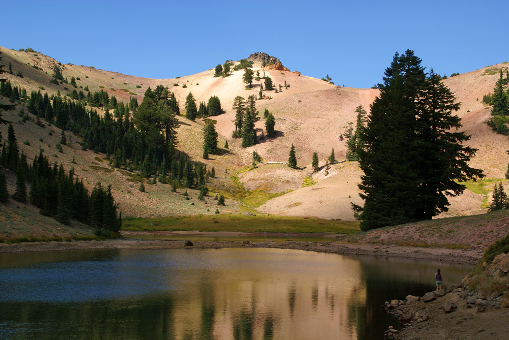
Ridge Lakes in Lassen Volcanic National Park, at the end of the hiking trail. Cross-country hiking to the ridge beyond is fairly easy.
The Ridge Lakes are quite beautiful, but the real reward comes when you hike cross-country beyond Ridge Lakes to the gap between Brokeoff Peak and Mount Diller, which offers a vista across the southern reaches of Lassen Volcanic National Park and way beyond in all directions.
This post starts with an exploration of Sulphur Works and then provides a detailed description of the Ridge Lakes Trail, along with a trail map and photos. The route is also Hike 105, “Ridge Lakes and Sulphur Works” in my book Day Hiking: Mount Shasta, Lassen & Trinity Alps Regions and Hike 31, “Mill Creek Falls and Ridge Lakes,” in my book 100 Classic Hikes: Northern California, fourth edition.
Ridge Lakes/Sulphur Works Trail Key Data
Distance: 2.2 miles roundtrip, plus optional 0.3 mile one-way cross-country climb to the ridge between Brokeoff Peak and Mount Diller
Difficulty: Strenuous because of the steepness of the trail
Type: Day hike or Overnight; backpackers need a permit
Elevation gain: 1000 feet
High point: 8000 feet
Season: July to early October, weather and snow permitting; Sulphur Works is accessible whenever the main Lassen Volcanic National Park road is open
Contact: Lassen Volcanic National Park
Maps: USGS Lassen Peak, park brochure
Permits: Permit required for backpackers: see park website or call for details and backcountry regulations
Notes: toilet at trailhead; dogs prohibited; watch children carefully at Sulphur Works, which has hot steam and hot water and mud pots
Ridge Lakes/Sulphur Works Trailhead Directions
Drive to the Sulphur Works parking lot, which is also the trailhead for the Ridge Lakes Trail. It’s on the Park Highway’s west side, 7.0 miles north of the junction of CA Highways 36 and 89, and 27.0 miles southeast of the junction of CA Highways 44 and 89.
Ridge Lakes/Sulphur Works Trailhead GPS coordinates: N 40′ 26.924″ W 121′ 32.143″
The Top 100 Day Hikes and Backpacking Trips in Northern California
The all-color fourth edition features the best trails in:
Northern Sierra Nevada
Lassen and Mount Shasta areas
Trinity Alps and Marble Mountains
Redwood Coast
Wine Country and Bay Area
Includes trailhead directions and detailed maps and trail descriptions
Often available at Barnes & Noble, REI, and other quality bookstoresand outdoor stores (call first!)
Exploring Sulphur Works
Sulphur Works is an impressive example of the hydrothermal activity in Lassen Volcanic National Park, and, unlike Bumpass Hell and Devil’s Kitchen, it’s right beside the park highway, so you don’t even have to hike to it.
Sulphur Works mud pot. Hydrothermal activity is common in Lassen Volcanic National Park.
Follow the acrid scent of hydrogen sulfide over to the Sulphur Works and its mud pots and fumaroles near Mount Tehama’s central vent. As interpretive panels explain, cool surface water descends to hot rock far below, then rises as hot water and steam around you. When Mount Tehama rose to an estimated elevation of over 11,000 feet, it held undisputed bragging rights as the biggest volcano south of Mount Shasta. Alas, glaciers eroded much of Mount Tehama; Brokeoff Mountain, rising to a height of 9235 feet due west, is its highest remaining fragment.
Sulphur Works steam vent and sulphur deposits. Hydrothermal activity gives evidence of the volcanic nature of Lassen Volcanic National Park.
Video: Sulphur Works, Lassen Volcanic National Park Geologic Wonder
Ridge Lakes in Lassen Volcanic National Park. View from above while climbing to the ridge.
Return to the north side of the parking lot and begin the Ridge Lakes Trail. The steep path heads up a ridge between two forks of West Sulphur Creek all the way to the lakes. At the beginning, you quickly reach the crest, where coyote mint, lupines, mule ears, and ferns grow in abundance, and from which you can gaze down upon Sulphur Works. As you continue, you’ll spy Brokeoff Mountain. On the probably frequent stops to lower your pulse rate, look behind for views of the Sierra Nevada, the Mill Creek drainage, and southern Lassen Volcanic National Park landmarks.
You soon weave in and out of forest shade provided by red firs and western white pines, and then spy a short side trail to the right at 0.3 mile that passes through a mountain alder thicket to a creek fork. The main path soon reenters a flower-strewn open area and then continues relentlessly up. Mountain hemlocks provide welcome company as you persevere. A glimpse north at the sharp slant of Mount Diller will make you grateful that the path isn’t any steeper than it is.
Ridge Lakes: End of the Trail
The Ridge Lakes await in a glacial cirque 1.0 mile from the trail’s beginning. Here you have a vista that includes Brokeoff Mountain and Mount Diller, plus the ridge that stretches between them. Brave swimmers will want to enter at the deepest section of the southern lake (the two are joined until late summer), and campers will find sheltered spots amid red fir and mountain mahogany on the northeast side of the lakes.
Beyond Ridge Lakes: Gap between Brokeoff Mountain and Mount Diller
Head up a gully on the northwest side of the lakes, where you’ll gain an easy 300 feet of elevation over 0.3 mile as you ascend to a ridge past partially decomposed volcanic rock. From the gap you’ll have a north and west panorama that runs from Mount Shasta to the Klamath Mountains, Coast Range, and Sacramento Valley; you’ll also see the southern portion of Lassen Volcanic National Park, along with Brokeoff Peak just to the south and Mount Diller just to the north.
Mount Diller from above Ridge Lakes, Lassen Volcanic National ParkBrokeoff Peak, a key Lassen Volcanic National Park landmark, from the ridge above Ridge Lakes
Want More Hiking in Lassen Volcanic National Park?
Like just about every other website on the planet, NCHT uses cookies. Continuing to use the site means you're OK with that.Cookie settingsACCEPT
Privacy & Cookies Policy
Privacy Overview
This website uses cookies to improve your experience while you navigate through the website. Out of these cookies, the cookies that are categorized as necessary are stored on your browser as they are essential for the working of basic functionalities of the website. We also use third-party cookies that help us analyze and understand how you use this website. These cookies will be stored in your browser only with your consent. You also have the option to opt-out of these cookies. But opting out of some of these cookies may have an effect on your browsing experience.
Necessary cookies are absolutely essential for the website to function properly. This category only includes cookies that ensures basic functionalities and security features of the website. These cookies do not store any personal information.
Any cookies that may not be particularly necessary for the website to function and is used specifically to collect user personal data via analytics, ads, other embedded contents are termed as non-necessary cookies. It is mandatory to procure user consent prior to running these cookies on your website.


 The all-color fourth edition features the best trails in:


 My compact guidebook has the 125 best day hikes:


%22%20transform%3D%22translate(.6%20.6)%20scale(1.17188)%22%20fill-opacity%3D%22.5%22%3E%3Cellipse%20fill%3D%22%23e2d5bf%22%20rx%3D%221%22%20ry%3D%221%22%20transform%3D%22rotate(-155%20112%2050)%20scale(117.46636%2046.71765)%22%2F%3E%3Cellipse%20fill%3D%22%23004cc3%22%20rx%3D%221%22%20ry%3D%221%22%20transform%3D%22matrix(252.06102%20-13.65114%201.97334%2036.43674%20139.2%209.9)%22%2F%3E%3Cellipse%20fill%3D%22%23261d19%22%20rx%3D%221%22%20ry%3D%221%22%20transform%3D%22matrix(-42.68706%2017.85638%20-11.82445%20-28.26725%20231.4%2055.8)%22%2F%3E%3Cellipse%20fill%3D%22%233674e2%22%20cx%3D%229%22%20cy%3D%2212%22%20rx%3D%2265%22%20ry%3D%2265%22%2F%3E%3C%2Fg%3E%3C%2Fsvg%3E "2024 Free Entrance Days at Northern California National Parks and Monuments")
%27%20fill-opacity%3D%27.5%27%3E%3Cellipse%20fill%3D%22%23f9f4ff%22%20fill-opacity%3D%22.5%22%20rx%3D%221%22%20ry%3D%221%22%20transform%3D%22matrix(91.31382%2066.02258%20-35.05562%2048.48435%2046.5%20157.6)%22%2F%3E%3Cpath%20fill%3D%22%23b8c768%22%20fill-opacity%3D%22.5%22%20d%3D%22M238.3%20231.9L140-24.1l129.1-49.6%2098.3%20256z%22%2F%3E%3Cellipse%20fill%3D%22%23b4aece%22%20fill-opacity%3D%22.5%22%20rx%3D%221%22%20ry%3D%221%22%20transform%3D%22rotate(-113.2%20136.3%2016.5)%20scale(262.7941%2029.81633)%22%2F%3E%3Cellipse%20fill%3D%22%23d3e187%22%20fill-opacity%3D%22.5%22%20rx%3D%221%22%20ry%3D%221%22%20transform%3D%22rotate(49%20-28.4%2084)%20scale(111.55642%2038.65434)%22%2F%3E%3C%2Fg%3E%3C%2Fsvg%3E "Burney Falls January 2025 Hiking Trails Closure Details")


Leave a Reply