Mount Shasta Area | Lassen Area | Trinity Alps | Shasta-Trinity NF | Klamath NF | Redwood Coast | Wine Country | Bay Area | Sierra Nevada | Hiking Advice
Hiking to beautiful Burstarse Falls in Castle Crags Wilderness via the Pacific Crest Trail is an annual ritual for many North State hikers. Most come in spring, when warmer days melt the winter snow off the high granite peaks of Castle Crags, sending the cold water streaming down Burstarse Creek and over Burstarse Falls.
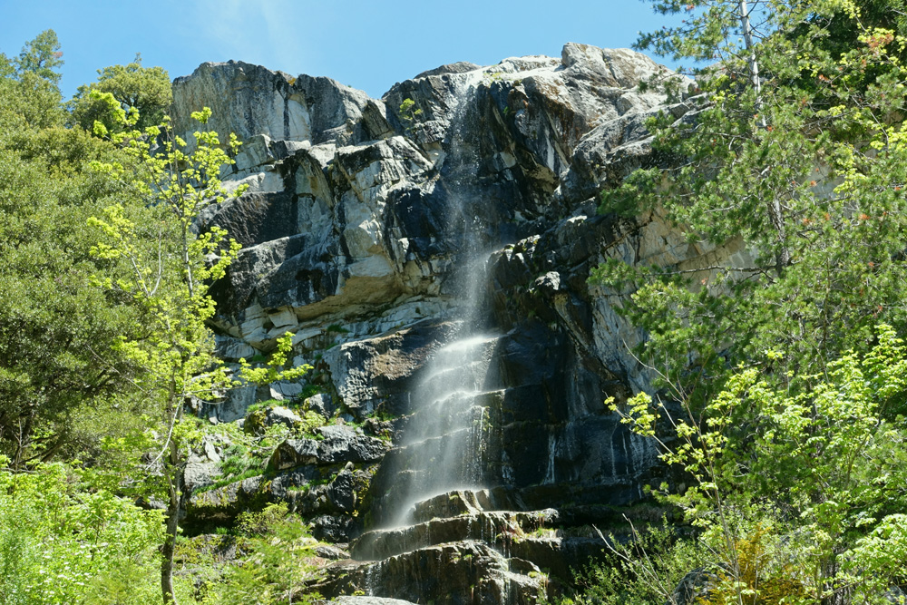
Burstarse Falls in early May of a low-snow year. They flow stronger earlier in spring when there’s more snow-melt from Castle Crags high above.
In addition to the beauty and solitude of Burstarse Falls, this hike offers open views of Castle Crags, Grey Rocks, Flume Creek Ridge, and other surrounding mountains. You’ll also visit shady Popcorn Spring and have opportunities to see dogwood in bloom in late spring, plus wildflowers in spring and summer. Note that you’ll need to do some steep slope scrambling and rock hopping to actually get to Burstarse Falls.
Burstarse Falls is in Two of My Hiking Guidebooks…
Distance: 5.2 miles round trip via the Dog Trail and the Pacific Crest Trail
Difficulty: Moderate, except for some more difficult cross-country scrambling to actually reach Burstarse Falls
Type: Day hike
Elevation gain: 1100 feet
High point: 3450 feet
Season: year-round; some winter snow; best in spring; Burstarse Falls flows strongest on warm spring days when the sun melts the snow high above in Castle Crags Wilderness
Contact: Mount Shasta Ranger Station, Shasta-Trinity National Forest
Maps: Mount Shasta Area map from Green Trails Maps, Castle Crags State Park brochure, USGS Dunsmuir
Permits: no permit needed
Notes: dogs allowed; horses allowed; mountain bikes prohibited (Pacific Crest Trail)
Burstarse Falls/Pacific Crest Trail — Dog Trail Trailhead Directions
Take the Castella/Castle Crags State Park exit off I-5 (Exit 724) about 48 miles north of Redding and 6 miles south of Dunsmuir. Go to the west side of the freeway and get on paved Castle Creek Road (Forest Road 25). Follow this road past Castle Crags State Park for about 3.2 miles to where you see a large scar from mining operations in the hillside on the right. Turn in and park at the Dog Trail trailhead.
Dog Trail Trailhead GPS coordinates: N 41 9.723 W 122 22.168
Trail map: Dog Trail to Pacific Crest Trail to Burstarse Falls. (Courtesy of Caltopo.com)Along the Dog Trail
Starting on the Dog Trail
To begin, go to the west side of the parking area (the left side as you drove in) where you’ll see the Dog Trail heading uphill. Why is it call the Dog Trail? The story I heard: it’s a way to get your dog on the Pacific Crest Trail because dogs are prohibited on trails in nearby Castle Crags State Park.
Rocky Dog Trail soon enters Castle Crags Wilderness and climbs steeply past chaparral and wildflowers for most of its 0.6 mile length as you get ever better views of the Castle Creek valley with Flume Creek Ridge and Grey Rocks to the south. You’ll also spy a few knobcone pines, hardy conifers that grow on poorer soils and only release seeds from their cones after a wildfire.
Dog Trail/Pacific Crest Trail Junction: Left for Burstarse Falls
Canyon live oaks shade the Pacific Crest Trail between Popcorn Spring and Burstarse Falls.
When the Dog Trail meets the Pacific Crest Trail, turn left on the PCT for the route to Burstarse Falls (although see below for information on hiking the Pacific Crest Trail easterly toward Sulphur Creek and Castle Crags State Park). For the rest of the hike, Douglas firs, ponderosa pines, incense cedars, and canyon live oaks provide substantial shade. Be sure to look up to your right to see the steep granitic peaks and domes of Castle Crags Wilderness.
Popcorn Spring
After traveling 1.0 mile along the PCT you’ll reach Popcorn Spring. Water glides serenely over smooth granite slabs under the shade of bigleaf maples and canyon live oaks, but nothing about this pretty yet ordinary water flow suggests popcorn.
Reaching Burstarse Creek
Six-tenths of a mile past Popcorn Spring you’ll have your first encounter with Burstarse Creek. (Look for a sign partially encased in tree bark on the right.) If you are a strong and agile hiker, you can hike upstream via a combination of faint paths and cross-country past two smaller waterfalls to get to Burstarse Falls, but read on for the main easier route.
Burstarse Creek Sign, Pacific Crest Trail, Castle Crags Wilderness. An alternate route to Burstarse Falls goes upstream from here.
Upward on the Pacific Crest Trail to Ugly Creek
As you continue climbing on the Pacific Crest Trail, views of Castle Crags continue to improve, and you’ll even get a glimpse of Burstarse Falls. About 0.5 mile from the crossing of Burstarse Creek you’ll reach the inappropriately named Ugly Creek. Granted, brushy manzanita and small oaks border its banks here, but its seasonal waters are clear and cool and no doubt pass through prettier scenery downstream.
Castle Crags viewed from the Pacific Crest Trail near Burstarse Falls. Views of Castle Crags get better the closer you get to the falls.
Best Day Hiking Trails in Upper California
Mycompact guidebook has the 125 best day hikes:
Mount Shasta and nearby
Lassen Volcanic National Park
Trinity Alps and Marble Mountains
Redding area
Whiskeytown and Shasta Lakes
Includes trailhead directions and detailed maps and trail descriptions
Buy it:on Amazon | on Bookshop.org Often available at bookstoresand outdoor stores (call first!)
The Final Push to Burstarse Falls
Two hundred yards past Ugly Creek the trail makes an abrupt 180-degree switchback. Burstarse Creek is 50 feet east of the trail, and the falls await you 100 yards upstream.
To get to Burstarse Falls, you must first get down to Burstarse Creek. Accomplish this by carefully making your way down the steep slope, being careful not to slip or brush against poison oak.
Once at the creek, go upstream along the far side (watch for poison oak), where a faint trail will guide you through the rocks. Take note of a small wading pool in the creek that offers a chance to cool off on hot days.
Burstarse Falls in All Its Glory!
After a couple of minutes of cross-country scrambling at the foot of a sheer rock wall, you’ll finally attain the main goal of the hike: Burstarse Falls, one of the most photographed Shasta-Trinity waterfalls. The falls boasts an unimpeded 40-foot drop, and makes the strongest impression during spring months when water flow is greatest due to melting snow on Castle Crags high above. However, even in other seasons the beautiful canyon and rock walls are well worth the visit, and you’ll always enjoy the shade and seclusion.
Burstarse Falls!
Heading Back: Consider Walking Burstarse Creek Downstream
You can reverse your steps and scramble back up to the Pacific Crest Trail above Ugly Creek. However, if you and everyone in your party is reasonably nimble, consider following Burstarse Creek downhill. You’ll pass beautiful streamside scenery and see two lesser waterfalls before meeting the Pacific Crest Trail and turning left to retrace your steps to the junction with the Dog Trail.
Side Hike to Sulphur Creek on the Pacific Crest Trail and Beyond
If you still have energy when you meet the Dog Trail, continue hiking eastward on the Pacific Crest Trail in the direction of Castle Crags State Park. A half-mile easy walk rewards you with both good views of Castle Crags plus the shaded banks of beautiful Sulphur Creek.
Looking south at Grey Rocks, from the Pacific Crest Trail
Hiking Down to the Dog Trail Trailhead
From the junction of the Dog Trail and the Pacific Crest Trail, it’s all downhill for 0.6 mile to the Dog Trail trailhead beside Castle Creek Road (Forest Road 25).
Want More Hiking in Nearby Castle Crags State Park?
John;
I have found doing the loop the other way to be much easier (it involves only uphill scampering) All uphill I find to be safer in that you know what your footing is going to be.
Like just about every other website on the planet, NCHT uses cookies. Continuing to use the site means you're OK with that.Cookie settingsACCEPT
Privacy & Cookies Policy
Privacy Overview
This website uses cookies to improve your experience while you navigate through the website. Out of these cookies, the cookies that are categorized as necessary are stored on your browser as they are essential for the working of basic functionalities of the website. We also use third-party cookies that help us analyze and understand how you use this website. These cookies will be stored in your browser only with your consent. You also have the option to opt-out of these cookies. But opting out of some of these cookies may have an effect on your browsing experience.
Necessary cookies are absolutely essential for the website to function properly. This category only includes cookies that ensures basic functionalities and security features of the website. These cookies do not store any personal information.
Any cookies that may not be particularly necessary for the website to function and is used specifically to collect user personal data via analytics, ads, other embedded contents are termed as non-necessary cookies. It is mandatory to procure user consent prior to running these cookies on your website.


 My compact guidebook has the 125 best day hikes:


%27%20fill-opacity%3D%27.5%27%3E%3Cellipse%20fill%3D%22%23f9f4ff%22%20fill-opacity%3D%22.5%22%20rx%3D%221%22%20ry%3D%221%22%20transform%3D%22matrix(91.31382%2066.02258%20-35.05562%2048.48435%2046.5%20157.6)%22%2F%3E%3Cpath%20fill%3D%22%23b8c768%22%20fill-opacity%3D%22.5%22%20d%3D%22M238.3%20231.9L140-24.1l129.1-49.6%2098.3%20256z%22%2F%3E%3Cellipse%20fill%3D%22%23b4aece%22%20fill-opacity%3D%22.5%22%20rx%3D%221%22%20ry%3D%221%22%20transform%3D%22rotate(-113.2%20136.3%2016.5)%20scale(262.7941%2029.81633)%22%2F%3E%3Cellipse%20fill%3D%22%23d3e187%22%20fill-opacity%3D%22.5%22%20rx%3D%221%22%20ry%3D%221%22%20transform%3D%22rotate(49%20-28.4%2084)%20scale(111.55642%2038.65434)%22%2F%3E%3C%2Fg%3E%3C%2Fsvg%3E "Burney Falls January 2025 Hiking Trails Closure Details")


%22%20transform%3D%22translate(.6%20.6)%20scale(1.17188)%22%20fill-opacity%3D%22.5%22%3E%3Cellipse%20fill%3D%22%23e2d5bf%22%20rx%3D%221%22%20ry%3D%221%22%20transform%3D%22rotate(-155%20112%2050)%20scale(117.46636%2046.71765)%22%2F%3E%3Cellipse%20fill%3D%22%23004cc3%22%20rx%3D%221%22%20ry%3D%221%22%20transform%3D%22matrix(252.06102%20-13.65114%201.97334%2036.43674%20139.2%209.9)%22%2F%3E%3Cellipse%20fill%3D%22%23261d19%22%20rx%3D%221%22%20ry%3D%221%22%20transform%3D%22matrix(-42.68706%2017.85638%20-11.82445%20-28.26725%20231.4%2055.8)%22%2F%3E%3Cellipse%20fill%3D%22%233674e2%22%20cx%3D%229%22%20cy%3D%2212%22%20rx%3D%2265%22%20ry%3D%2265%22%2F%3E%3C%2Fg%3E%3C%2Fsvg%3E "2024 Free Entrance Days at Northern California National Parks and Monuments")


John;
I have found doing the loop the other way to be much easier (it involves only uphill scampering) All uphill I find to be safer in that you know what your footing is going to be.