Mount Shasta Area | Lassen Area | Trinity Alps | Shasta-Trinity NF | Klamath NF | Redwood Coast | Wine Country | Bay Area | Sierra Nevada | Hiking Advice
Hiking the levee trails along Big Lake, Horr Pond, and the Tule River in the Fall River Valley near McArthur rewards you with views of Lassen Peak and Mount Shasta, plus an abundance of wildlife.
Vista of Horr Pond and, from left to right, Lassen Peak, Thousand Lakes Wilderness, and Burney Mountain. (Photo by Garrett Costello)
Hiking Big Lake, Horr Pond, and Tule River Trails: Key Data
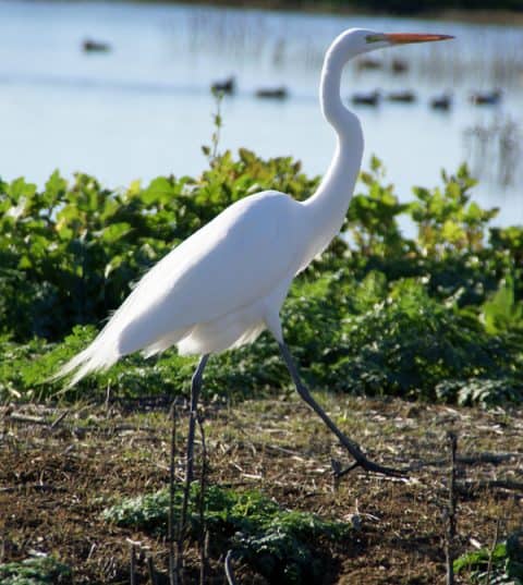
Great Egret: a resident bird at Big Lake and Horr Pond
Distance: up to 8 miles round trip
Difficulty: Easy
Type: Day hike
Elevation gain: insignificant
High point: 3300 feet
Season: year-round as weather conditions permit; hunting season runs from early October to mid-January
Contact: Recreation Department, PG&E
Maps: USGS 7.5′ Fall River Mills
Big Lake/Horr Pond Trailhead GPS coordinates: N 41 06.002 W 121 24.729
Notes: pit toilet at trailhead
Driving Directions to the Big Lake and Horr Pond Trailhead
Drive CA Highway 299 to the Fall River Valley and the small town of McArthur. Go north on Main Street past the fairgrounds to a dirt road. At 0.5 mile, go right and pass through a gate. The good gravel road continues north another 3.0 miles to the parking area at Rat Farm.
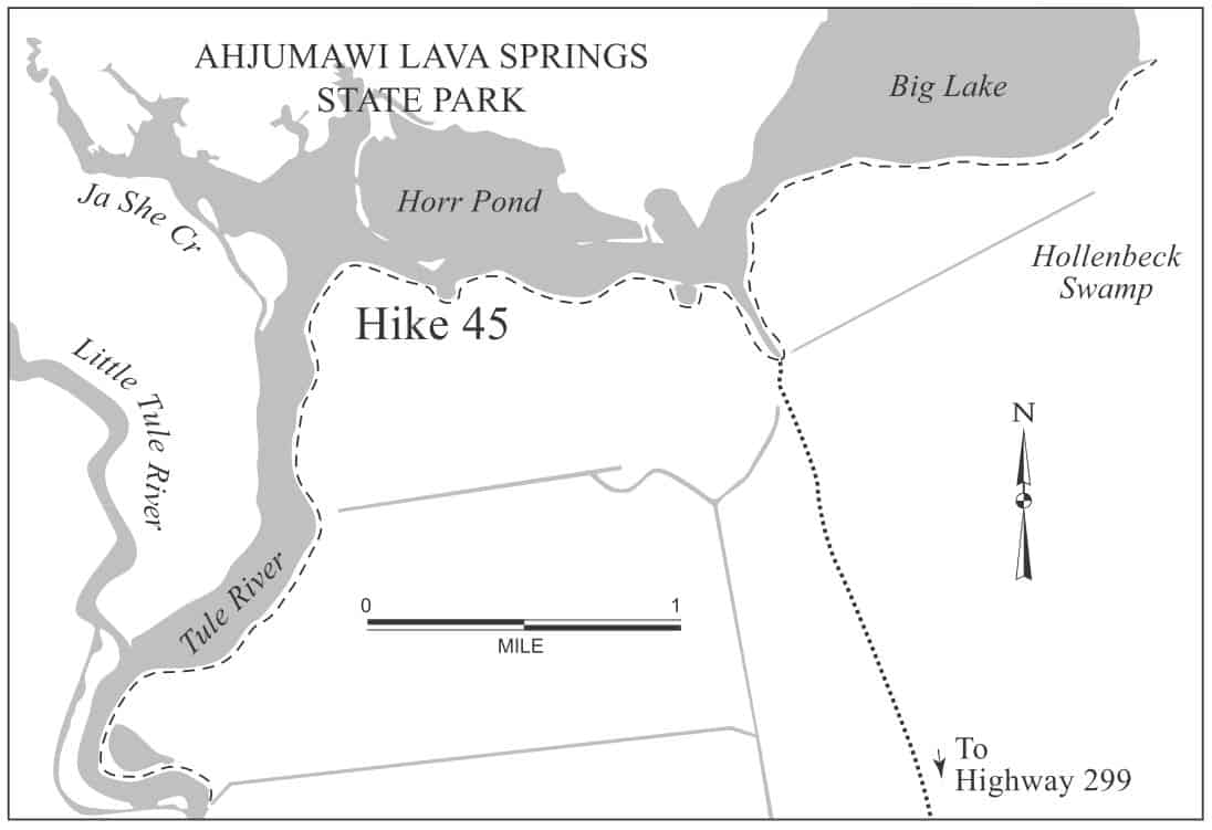
Big Lake, Horr Pond, and Tule River Levee hiking trail map: heart of the Fall River Valley in northeastern California
Big Lake, Horr Pond, and Tule River: Birds, Birds, Birds!
This level levee walk features a full range of sensual delights: the smell and taste of fresh mountain air tinged with tangy juniper scent; the feel of the wind bringing cool water vapor to the cheek; the sound of Canada geese, mallards, and redtailed hawks calling out to each other and the world; the sight of volcanoes—far and near, large and small—ringing the Fall River Valley.
Best Day Hiking Trails in Upper California
Mycompact guidebook has the 125 best day hikes:
Mount Shasta and nearby
Lassen Volcanic National Park
Trinity Alps and Marble Mountains
Redding area
Whiskeytown and Shasta Lakes
Includes trailhead directions and detailed maps and trail descriptions
Buy it:on Amazon | on Bookshop.org Often available at bookstoresand outdoor stores (call first!)
As you explore the shores of Big Lake and Horr Pond, the large number and variety of birds will astound you. Through the middle of spring, the area hosts large numbers of migratory birds that feed in nearby fields (such as Hollenbeck Swamp just south of Big Lake). The sudden rise of a thousand snow geese, accompanied by a chaotic chorus of high-pitched cries, can be the high point of your day, or your year. Many other species are winter/spring or year-round residents, including Canada goose, cackling goose, Pacific white-fronted goose, cinnamon teal, green-winged teal, northern pintail, and northern shoveler. You’ll also see numerous great blue herons and quite possibly some osprey. If you’re lucky, you’ll spot the relatively rare white pelican or greater sandhill crane.
Big Lake Hiking Trail/Levee
You have two hiking options. The first leaves along the right-hand side of the narrow water channel by the Rat Farm parking area and initially heads north towards Ahjumawi Lava Springs State Park (also has great hiking trails). The path soon bends east to hug the southern shore of Big Lake for a mile. Like many of the rivers and lakes in the Fall River Valley, Big Lake and Horr Pond owe their existence to the porous lava rock that makes up much of the Modoc Plateau of northeastern California. Water from the Tule Lake region 50 miles to the north travels underground to emerge here.
Horr Pond Trail vista: Mount Shasta and Ahjumawi Lava Springs State Park. (Courtesy Wikimedia)
Horr Pond Hiking Trail/Levee to Tule River
The left-hand trail leaves the parking area to run north and then west for over a mile along the shore of Horr Pond. Here you have unimpeded views of Mount Shasta’s snowy crown to the northwest, Soldier Mountain topping the western edge of the Fall River Valley, and a string of massive volcanoes stretching south from Burney Mountain to Crater and Magee Peaks and then to Lassen Peak and Chaos Crags. The levee soon curves south to travel nearly 2 miles along the banks of the Tule River. Now, in addition to having the mountain views, you’ll see pastoral settings of barn and field, reminders of the broad valley’s fertility.
Canoes, Kayaks, Other Boats on Big Lake, Horr Pond, and Tule River
When you’re done hiking the levees, consider taking a canoe or kayak out on Big Lake and Horr Pond. Once on the water, you can explore wherever you want, including heading over to Ahjumawi Lava Springs State Park for more hiking.
Your Take: Big Lake, Horr Pond, and Tule River
What was your experience? Let us know in the comments below.
Camp for Free in California National Forests
California’s national forests and BLM lands have thousands of miles of dirt roads with lots of spots for dispersed camping (boondocking). My book provides all the info you need to get started (but is not a guide to specific sites):
Like just about every other website on the planet, NCHT uses cookies. Continuing to use the site means you're OK with that.Cookie settingsACCEPT
Privacy & Cookies Policy
Privacy Overview
This website uses cookies to improve your experience while you navigate through the website. Out of these cookies, the cookies that are categorized as necessary are stored on your browser as they are essential for the working of basic functionalities of the website. We also use third-party cookies that help us analyze and understand how you use this website. These cookies will be stored in your browser only with your consent. You also have the option to opt-out of these cookies. But opting out of some of these cookies may have an effect on your browsing experience.
Necessary cookies are absolutely essential for the website to function properly. This category only includes cookies that ensures basic functionalities and security features of the website. These cookies do not store any personal information.
Any cookies that may not be particularly necessary for the website to function and is used specifically to collect user personal data via analytics, ads, other embedded contents are termed as non-necessary cookies. It is mandatory to procure user consent prior to running these cookies on your website.


 My compact guidebook has the 125 best day hikes:
 California’s national forests and BLM lands have thousands of miles of dirt roads with lots of spots for dispersed camping (boondocking). My book provides all the info you need to get started (but is not a guide to specific sites):
%27%20fill-opacity%3D%27.5%27%3E%3Cellipse%20fill%3D%22%23f9f4ff%22%20fill-opacity%3D%22.5%22%20rx%3D%221%22%20ry%3D%221%22%20transform%3D%22matrix(91.31382%2066.02258%20-35.05562%2048.48435%2046.5%20157.6)%22%2F%3E%3Cpath%20fill%3D%22%23b8c768%22%20fill-opacity%3D%22.5%22%20d%3D%22M238.3%20231.9L140-24.1l129.1-49.6%2098.3%20256z%22%2F%3E%3Cellipse%20fill%3D%22%23b4aece%22%20fill-opacity%3D%22.5%22%20rx%3D%221%22%20ry%3D%221%22%20transform%3D%22rotate(-113.2%20136.3%2016.5)%20scale(262.7941%2029.81633)%22%2F%3E%3Cellipse%20fill%3D%22%23d3e187%22%20fill-opacity%3D%22.5%22%20rx%3D%221%22%20ry%3D%221%22%20transform%3D%22rotate(49%20-28.4%2084)%20scale(111.55642%2038.65434)%22%2F%3E%3C%2Fg%3E%3C%2Fsvg%3E "Burney Falls January 2025 Hiking Trails Closure Details")

%22%20transform%3D%22translate(.6%20.6)%20scale(1.17188)%22%20fill-opacity%3D%22.5%22%3E%3Cellipse%20fill%3D%22%23e2d5bf%22%20rx%3D%221%22%20ry%3D%221%22%20transform%3D%22rotate(-155%20112%2050)%20scale(117.46636%2046.71765)%22%2F%3E%3Cellipse%20fill%3D%22%23004cc3%22%20rx%3D%221%22%20ry%3D%221%22%20transform%3D%22matrix(252.06102%20-13.65114%201.97334%2036.43674%20139.2%209.9)%22%2F%3E%3Cellipse%20fill%3D%22%23261d19%22%20rx%3D%221%22%20ry%3D%221%22%20transform%3D%22matrix(-42.68706%2017.85638%20-11.82445%20-28.26725%20231.4%2055.8)%22%2F%3E%3Cellipse%20fill%3D%22%233674e2%22%20cx%3D%229%22%20cy%3D%2212%22%20rx%3D%2265%22%20ry%3D%2265%22%2F%3E%3C%2Fg%3E%3C%2Fsvg%3E "2024 Free Entrance Days at Northern California National Parks and Monuments")


Leave a Reply