Mount Shasta Area | Lassen Area | Trinity Alps | Shasta-Trinity NF | Klamath NF | Redwood Coast | Wine Country | Bay Area | Sierra Nevada | Hiking Advice
Day hike or backpack to the twin summits capping Snow Mountain Wilderness for expansive views of Berryessa Snow Mountain National Monument and much of Northern California.
2020: Snow Mountain Wilderness Trails Closed Due to 2018 Ranch Fire through all of 2020
In 2018 the Mendocino Complex Fire, which included the Ranch Fire, burned through much of this area. Mendocino National Forest has closed the area until roads and trails can be rehabilitated, with the earliest possible open date being summer of 2021. Definitely call the Grindstone Ranger District first!
Snow Mountain East viewed from the summit of Snow Mountain West
Snow Mountain Summits Key Data
Length: 8.0 miles round-trip
Hiking time: 6 hours or overnight backpacking trip
High point: 7,056 feet
Total elevation gain: 2,150 feet
Difficulty: moderate
Season: mid-June to early October
Water: essentially none; bring plenty of your own
Summit Springs Trailhead GPS coordinates: N 39 20.745 W 122 45.124
Maps: USGS 7.5’ Potato Hill, USGS 7.5’ Fouts Springs, USGS 7.5’ St. John Mountain, USGS 7.5’ Crockett Peak
Information: Grindstone Ranger District, Mendocino National Forest
Notes: dogs allowed, backpackers will find many level spots and will need a California campfire permit
Driving Directions to the Snow Mountain/Summit Springs Trailhead
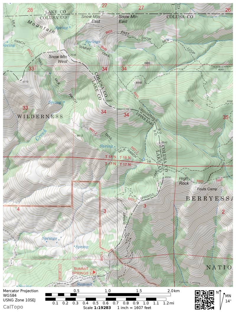
Reach the town of Stonyford by exiting Interstate 5 at either Maxwell or Willows. Take Forest Road M-10 (18N01), which is initially called Fouts Springs Road, and follow signs for Snow Mountain and Summit Springs. After 24 miles turn right at a “Trailhead 1” sign for the final, steep 1.4 miles to the Summit Springs trailhead parking area.
Trail map from Summit Springs to the twin summits of Snow Mountain. (Courtesy of Caltopo.com)
Hiking the Snow Mountain Trail in Snow Mountain Wilderness
The trip to the twin summits of Snow Mountain offers scenery that includes serene forests of pine and fir, a psychedelic assortment of multihued rocks, and sweeping vistas of mountains and valleys stretching to the far horizons, a vista that includes the Berryessa Snow Mountain National Monument, created in 2015.
The path begins in a small forest of Jeffrey pine and white fir and quickly enters open areas created by a huge wildfire in 1987. As you climb over the next mile, note the variety of shrubs and other plants that have begun a long process of succession, which should eventually restore much of this area to forest.
The Top 100 Day Hikes and Backpacking Trips in Northern California
The all-color fourth edition features the best trails:
Northern Sierra Nevada
Lassen and Mount Shasta areas
Trinity Alps and Marble Mountains
Redwood Coast
Wine Country and Bay Area
Includes trailhead directions and detailed maps and trail descriptions
Often available at Barnes & Noble, REI, and other quality bookstoresand outdoor stores (call first!)
Climbing High Rock
Go left at a trail fork at 0.7 mile, and then cross two small, seasonal creeks at 1.0 mile. Next, switchback uphill to a ridge at 1.5 miles. Look to the right for High Rock, about 300 yards east of the trail; it offers expansive westward, southward, and eastward views similar to those of the destination summits, lacking only a northward vista.
Reaching Cedar Camp
The path now climbs along the ridge, passing through a forest of Jeffrey pine and red and white fir. Ignore the other faint trails that disappear into the trees. Continue to Cedar Camp at 1.9 miles, which has a green meadow, an excellent campsite beside a small pond, and no cedars. Bear right here at a trail fork.
After a steady ascent through the forest, substantial parts heavily damaged by past wildfire, enter the open, glaciated basin below Snow Mountain’s summits. Climb steadily 0.7 mile to the saddle between the two summits, and then turn left at a three-way trail junction.
Snow Mountain West
After a brief climb, reach the 7,038-foot summit of Snow Mountain West. From here, you have northward views of Mount Linn, Mount Shasta, and the Klamath Mountains; eastward views of Stony Creek Gorge, the Sacramento Valley, Sutter Buttes, the Cascades, and the Sierra Nevada; and southward and westward views of endless chains of Coast Range ridges and peaks. Be sure to look at the odd assortment of green, gray, and purple metamorphic rocks at your feet.
Snow Mountain East
After you’ve rested and enjoyed the view, go back to the saddle and take the right-hand trail up to the 7,056-foot summit of Snow Mountain East, which offers views similar to those of its sibling.
If you have the ambition, consider camping on one of the summits (and follow Leave No Trace principles). You’ll have far-reaching, earthly views during the day and an open universe above at night. Bring all the water you’ll need, be prepared for possible high winds, and head downhill into the relative safety of the forest if a thunderstorm threatens.
Snow Mountain Wilderness from the Sacramento National Wildlife Refuge in winter.
Camp for Free in California National Forests
California’s national forests and BLM lands have thousands of miles of dirt roads with lots of spots for dispersed camping (boondocking). My book provides all the info you need to get started (but is not a guide to specific sites):
Like just about every other website on the planet, NCHT uses cookies. Continuing to use the site means you're OK with that.Cookie settingsACCEPT
Privacy & Cookies Policy
Privacy Overview
This website uses cookies to improve your experience while you navigate through the website. Out of these cookies, the cookies that are categorized as necessary are stored on your browser as they are essential for the working of basic functionalities of the website. We also use third-party cookies that help us analyze and understand how you use this website. These cookies will be stored in your browser only with your consent. You also have the option to opt-out of these cookies. But opting out of some of these cookies may have an effect on your browsing experience.
Necessary cookies are absolutely essential for the website to function properly. This category only includes cookies that ensures basic functionalities and security features of the website. These cookies do not store any personal information.
Any cookies that may not be particularly necessary for the website to function and is used specifically to collect user personal data via analytics, ads, other embedded contents are termed as non-necessary cookies. It is mandatory to procure user consent prior to running these cookies on your website.


 The all-color fourth edition features the best trails:
 California’s national forests and BLM lands have thousands of miles of dirt roads with lots of spots for dispersed camping (boondocking). My book provides all the info you need to get started (but is not a guide to specific sites):
%22%20transform%3D%22translate(.6%20.6)%20scale(1.17188)%22%20fill-opacity%3D%22.5%22%3E%3Cellipse%20fill%3D%22%23e2d5bf%22%20rx%3D%221%22%20ry%3D%221%22%20transform%3D%22rotate(-155%20112%2050)%20scale(117.46636%2046.71765)%22%2F%3E%3Cellipse%20fill%3D%22%23004cc3%22%20rx%3D%221%22%20ry%3D%221%22%20transform%3D%22matrix(252.06102%20-13.65114%201.97334%2036.43674%20139.2%209.9)%22%2F%3E%3Cellipse%20fill%3D%22%23261d19%22%20rx%3D%221%22%20ry%3D%221%22%20transform%3D%22matrix(-42.68706%2017.85638%20-11.82445%20-28.26725%20231.4%2055.8)%22%2F%3E%3Cellipse%20fill%3D%22%233674e2%22%20cx%3D%229%22%20cy%3D%2212%22%20rx%3D%2265%22%20ry%3D%2265%22%2F%3E%3C%2Fg%3E%3C%2Fsvg%3E "2024 Free Entrance Days at Northern California National Parks and Monuments")


%27%20fill-opacity%3D%27.5%27%3E%3Cellipse%20fill%3D%22%23f9f4ff%22%20fill-opacity%3D%22.5%22%20rx%3D%221%22%20ry%3D%221%22%20transform%3D%22matrix(91.31382%2066.02258%20-35.05562%2048.48435%2046.5%20157.6)%22%2F%3E%3Cpath%20fill%3D%22%23b8c768%22%20fill-opacity%3D%22.5%22%20d%3D%22M238.3%20231.9L140-24.1l129.1-49.6%2098.3%20256z%22%2F%3E%3Cellipse%20fill%3D%22%23b4aece%22%20fill-opacity%3D%22.5%22%20rx%3D%221%22%20ry%3D%221%22%20transform%3D%22rotate(-113.2%20136.3%2016.5)%20scale(262.7941%2029.81633)%22%2F%3E%3Cellipse%20fill%3D%22%23d3e187%22%20fill-opacity%3D%22.5%22%20rx%3D%221%22%20ry%3D%221%22%20transform%3D%22rotate(49%20-28.4%2084)%20scale(111.55642%2038.65434)%22%2F%3E%3C%2Fg%3E%3C%2Fsvg%3E "Burney Falls January 2025 Hiking Trails Closure Details")


Leave a Reply