Mount Shasta Area | Lassen Area | Trinity Alps | Shasta-Trinity NF | Klamath NF | Redwood Coast | Wine Country | Bay Area | Sierra Nevada | Hiking Advice
Hike the Pacific Crest Trail from Echo Lakes into Desolation Wilderness and to Lake Aloha, Lake of the Woods, and Ropi Lake, all under the jagged granite of Pyramid Peak, Mount Agassiz, and Mount Price. Backpackers and day hikers will find all the relevant info in this post, which is based on Hike 6 of my book 100 Classic Hikes: Northern California, fourth edition.
Pyramid Peak Above Lake Aloha, Desolation Wilderness
Echo Lakes to Lake Aloha Key Data
Distance: 11.3 miles roundtrip
Difficulty: Moderate
Type: Day hike or 2- to 3-day backpacking trip
Elevation gain: 2200 feet feet
High point: 8350 feet
Season: July to October, or earlier in years with low snowfall
Contact: Lake Tahoe Basin Management Unit
Maps: USGS Echo Lake, USGS Pyramid Peak, Desolation Wilderness by Tom Harrison Maps
Trailhead GPS coordinates: N 38 50.021 W 120 02.564
Notes: Dogs allows on-leash. Free day-hiker permit at trailhead. Distance and elevation based on taking the water taxi across Echo Lakes. Toilet near trailhead.
The Top 100 Day Hikes and Backpacking Trips in Northern California
The all-color fourth edition features the best trails:
Northern Sierra Nevada
Lassen and Mount Shasta areas
Trinity Alps and Marble Mountains
Redwood Coast
Wine Country and Bay Area
Includes trailhead directions and detailed maps and trail descriptions
Often available at Barnes & Noble, REI, and other quality bookstoresand outdoor stores (call first!)
Desolation Wilderness Permits: Backpacking and Day Hiking
You must have a permit and pay a fee for all overnight trips in Desolation Wilderness. It’s best to obtain your permit from www.recreation.gov. (Be sure to print it out and have it with you on your trip.) There are also a limited number of same-day permits available on a first-come, first-served basis at the following locations:
1. Taylor Creek Visitor Center, located on CA Highway 89 on the west side, 3.2 miles north of the junctions of CA Highway 89 and US Highway 50 in South Lake Tahoe (24.4 miles south of the intersections of CA Highways 89 and 28). Open daily from Memorial Day through October. 530-543-2674.
2. Lake Tahoe Basin Management Unit supervisor’s office, located at 35 College Drive in South Lake Tahoe. Open weekdays year-round. 530-543-2600.
3. Pacific Ranger District, Eldorado National Forest, located 4 miles east of Pollock Pines on US Highway 50. Open daily from Memorial Day weekend through the end of September; open weekdays the rest of the year. 530-644-2349.
4. Incline Village office, located at 855 Alder Street in Incline Village, Nevada, on Lake Tahoe’s north shore. Open Wednesday through Friday year-round. 775-831-0914.
Note that day hikers also need a permit; these are available for free at all major trailheads.
Bear Canisters Are Required for Desolation Wilderness Backpacking/Overnight Trips
As of July 18, 2022, all people backpacking/staying overnight in Desolation Wilderness must have and use a bear canister to store food. Bears in the area can now easily get to food hung in trees, so bear canisters are now the only viable solution for keeping your food safe.
Backpackers can rent bear canisters at the Placerville Ranger Station at the same time they obtain a permit. (More info: 530-647-5415). You can buy good bear canisters at outdoor stores like REI, and you can order online from Amazon and other retailers.
Drive US Highway 50 for 5.1 miles southwest of its southerly intersection with CA Highway 89 and 1.8 miles east of the Sierra at Tahoe Resort, and then take the road on the north side of Highway 50 signed for Berkeley Camp and Echo Lake. Drive 0.6 mile, bear left onto Echo Lakes Road, and then take another immediate left. Continue another 0.9 mile to the large and often crowded trailhead on the left.
Trail map: Lake Aloha, Ralston Lake, Ropi Lake, Tamarack Lake, Pacific Crest Trail
Hiking the Pacific Crest Trail From Echo Lakes to Lake Aloha
This hike offers the easiest way to immerse yourself in the sublime beauty of the numerous lakes and peaks that highlight granitic Desolation Valley. Lake Aloha and the Crystal Range rank as the main draws, but numerous other lakes and peaks will compete for your attention.
Echo Lake Chalet Water Taxi
Begin by taking the water taxi from the dock at Echo Lake Chalet on the southwest edge of Lower Echo Lake. Since the fares and policies of the water taxi can change over time, see the chalet’s main website for details. (If you are not able to take the water taxi, you’ll need to hike the Pacific Crest Trail for a gentle 2.5-mile climb to near the northwest edge of Upper Echo Lake, adding a total of 5.0 miles to the trip.)
Echo Lakes from the Pacific Crest Trail Near Desolation Wilderness
Begin Hiking on the Pacific Crest Trail
Take the short connector trail up to the Pacific Crest Trail and go left. Begin a substantial climb through country that allows good views of the Echo Lakes and the surrounding rocky peaks. Stay left on the PCT at 0.6 mile.
Camp for Free in California National Forests
California’s national forests and BLM lands have thousands of miles of dirt roads with lots of spots for dispersed camping (boondocking). My book provides all the info you need to get started (but is not a guide to specific sites):
At 1.1 miles a trail heads left from the PCT. (This makes an excellent side trip either now or on your way back. A 0.2-mile stroll brings you to Tamarack Lake. A granite wall, laced with communities of fir and western white pine, rises above the far side of the lake, topped by the steepest flank of 9235-foot Ralston Peak. The trail skirts the east shoreline, crosses the outlet stream, and then passes near the marshy south side of the lake. Climb the faint trail 0.2 mile to overlook Ralston Lake, nestled below Ralston Peak. This pristine, deep lake and neighboring Cagwin Lake offer excellent swimming and a few campsites.)
Pacific Crest Trail to Lake Aloha
For the main hike, continue northwest on the PCT at 1.1 miles and climb even more over the next 0.6 mile to another trail fork. Stay left on the PCT and soon enter Haypress Meadows. Continue on the well-signed PCT past a series of trail forks until you finally reach the southeast shore of Lake Aloha and a trail fork at 3.4 miles. With its vast expanse of water dotted with dozens of granite islands, all flanked by Pyramid Peak and other promontories of the Crystal Range to the west, Lake Aloha is one of the most visually stunning lakes in the Sierra Nevada. However, it is not a natural lake. A dam raises water levels in the Desolation Valley, flooding several small lakes to create the larger lake.
Continuing northwest along the PCT would bring you to the trails of Hikes 11 (Susie Lake, Heather Lake, and Lake Aloha) and 13 (Dicks Lake, Gilmore Lake, Lake Aloha, and Middle Velma Lake), both discussed below. However, go left and southerly for a scenic shoreline stroll. Note the western white pine and mountain hemlock thriving on the countless granite rock islands in Lake Aloha, and also note a few campsites a short distance from the lake.
Hikers at Lake Aloha, Desolation Wilderness
Lake of the Woods and Ropi Lake Trail
Bear left at 4.0 miles, continue southeast by going left at a trail fork at 4.6 miles, and then reach, at 4.9 miles, the north shore of aptly named Lake of the Woods, which rivals Lake Aloha in popularity because of its numerous campsites. The path goes east to an important trail fork at 5.3 miles at the northeast corner of the lake. You’ll eventually take the left path to get back to the PCT. For now, proceed straight and arc around the east shore.
At 5.8 miles the trail departs Lake of the Woods and heads south 0.3 mile onto a flat. You soon cross the Lake of the Woods outlet stream. Head due west, just south of a steep cliff. At 6.9 miles arrive at rocky Ropi Lake, which has several places to camp. This attractive lake invites a circumnavigating trek that is highlighted by views of Pyramid Peak. Consider easy cross-country walks to Toem Lake (west) and Avalanche Lake (south).
To return to the trailhead, retrace your steps 1.6 miles to the junction at the northeast tip of Lake of the Woods. Turn right here and climb for 0.5 mile, and then go straight at a trail intersection with the Ralston Peak Trail. Hike down into Haypress Meadows, and then head right 0.2 mile farther when you reach the PCT. From here it is 2.1 miles to the northwest shore of Upper Echo Lake, where you can catch the water taxi.
Sierra Juniper Above Echo Lakes Near Desolation Wilderness
Explore More Desolation Wilderness Backpacking Trails
You have many opportunities for more hiking in the Desolation Wilderness. Your best bets: head to the north shore of Lake Aloha on the PCT to connect with Hike 11 (Susie Lake, Heather Lake, and Lake Aloha) and 13 (Dicks Lake, Gilmore Lake, Lake Aloha, and Middle Velma Lake) and Hike 13 (Dicks Lake, Gilmore Lake, Lake Aloha, and Middle Velma Lake). All three hikes are described in my book 100 Classic Hikes: Northern California, fourth edition. Also see the side trip to Tamarack and Ralston Lakes described above.
The Top 100 Day Hikes and Backpacking Trips in Northern California
The all-color fourth edition features the best trails:
Northern Sierra Nevada
Lassen and Mount Shasta areas
Trinity Alps and Marble Mountains
Redwood Coast
Wine Country and Bay Area
Includes trailhead directions and detailed maps and trail descriptions
Often available at Barnes & Noble, REI, and other quality bookstoresand outdoor stores (call first!)
Lake Aloha via Horsetail Falls: My First Backpacking Trip
I actually first hiked to Lake Aloha as a teenager with my older brothers Marc Soares and Eric Soares. Back then we didn’t like to do things the easy way. We parked on Highway 50 and schlepped our heavy packs straight up the mountainside near Pyramid Creek and past Horsetail Falls on a steep and very faint trail that eventually gave way to cross-country hiking. We passed Ropi Lake, Toem Lake, and American Lake on the way to Lake Aloha. Don’t know why we didn’t take the far easier routes, like the one described here, but I wasn’t the one planning the trip.
Your Take: Echo Lakes to Lake Aloha
Have you done the trip? Your thoughts?
Subscribe to the Northern California Hiking Trails Blog
I find the horsetail falls route much more enjoyable. Following pyramid creek up past Ropi past Desolation Lake and Channel Lakes to American and Aloha. Much less crowded. Scenic as all hell. And all and all more of a wilderness adventure.
But either way a great destination with plenty of awesome lakes. Nice job.
Hi John, thanks for the great outline! I’m considering a portion of this hike in late May-early June to take my daughter on her first backpacking trip. She’s a good hiker, but has never backpacked. What portion(s) of this hike do you think would be a good introduction to backpacking? We thinking 5-8 miles roundtrip. Fishing would be great, if you have any knowledge of which if any of these lakes hold trout.
Thank you, and I’m glad you’re getting your daughter out backpacking! You could go straight to Lake of the Woods to camp, and then do a day hike the next day to Lake Aloha. I’m not an expert on fishing: consider Googling fishing in Desolation Wilderness, or perhaps find a California fishing group on Facebook.
Do check snow levels before you go. Your time seems too early, this year especially. Better if you can wait until mid-July or later.
Like just about every other website on the planet, NCHT uses cookies. Continuing to use the site means you're OK with that.Cookie settingsACCEPT
Privacy & Cookies Policy
Privacy Overview
This website uses cookies to improve your experience while you navigate through the website. Out of these cookies, the cookies that are categorized as necessary are stored on your browser as they are essential for the working of basic functionalities of the website. We also use third-party cookies that help us analyze and understand how you use this website. These cookies will be stored in your browser only with your consent. You also have the option to opt-out of these cookies. But opting out of some of these cookies may have an effect on your browsing experience.
Necessary cookies are absolutely essential for the website to function properly. This category only includes cookies that ensures basic functionalities and security features of the website. These cookies do not store any personal information.
Any cookies that may not be particularly necessary for the website to function and is used specifically to collect user personal data via analytics, ads, other embedded contents are termed as non-necessary cookies. It is mandatory to procure user consent prior to running these cookies on your website.


 The all-color fourth edition features the best trails:

 California’s national forests and BLM lands have thousands of miles of dirt roads with lots of spots for dispersed camping (boondocking). My book provides all the info you need to get started (but is not a guide to specific sites):
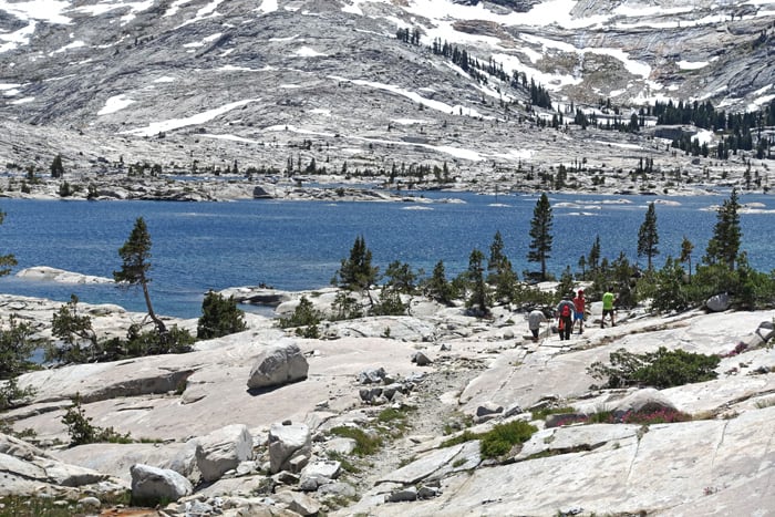


%22%20transform%3D%22translate(.6%20.6)%20scale(1.17188)%22%20fill-opacity%3D%22.5%22%3E%3Cellipse%20fill%3D%22%23e2d5bf%22%20rx%3D%221%22%20ry%3D%221%22%20transform%3D%22rotate(-155%20112%2050)%20scale(117.46636%2046.71765)%22%2F%3E%3Cellipse%20fill%3D%22%23004cc3%22%20rx%3D%221%22%20ry%3D%221%22%20transform%3D%22matrix(252.06102%20-13.65114%201.97334%2036.43674%20139.2%209.9)%22%2F%3E%3Cellipse%20fill%3D%22%23261d19%22%20rx%3D%221%22%20ry%3D%221%22%20transform%3D%22matrix(-42.68706%2017.85638%20-11.82445%20-28.26725%20231.4%2055.8)%22%2F%3E%3Cellipse%20fill%3D%22%233674e2%22%20cx%3D%229%22%20cy%3D%2212%22%20rx%3D%2265%22%20ry%3D%2265%22%2F%3E%3C%2Fg%3E%3C%2Fsvg%3E "2024 Free Entrance Days at Northern California National Parks and Monuments")
%27%20fill-opacity%3D%27.5%27%3E%3Cellipse%20fill%3D%22%23f9f4ff%22%20fill-opacity%3D%22.5%22%20rx%3D%221%22%20ry%3D%221%22%20transform%3D%22matrix(91.31382%2066.02258%20-35.05562%2048.48435%2046.5%20157.6)%22%2F%3E%3Cpath%20fill%3D%22%23b8c768%22%20fill-opacity%3D%22.5%22%20d%3D%22M238.3%20231.9L140-24.1l129.1-49.6%2098.3%20256z%22%2F%3E%3Cellipse%20fill%3D%22%23b4aece%22%20fill-opacity%3D%22.5%22%20rx%3D%221%22%20ry%3D%221%22%20transform%3D%22rotate(-113.2%20136.3%2016.5)%20scale(262.7941%2029.81633)%22%2F%3E%3Cellipse%20fill%3D%22%23d3e187%22%20fill-opacity%3D%22.5%22%20rx%3D%221%22%20ry%3D%221%22%20transform%3D%22rotate(49%20-28.4%2084)%20scale(111.55642%2038.65434)%22%2F%3E%3C%2Fg%3E%3C%2Fsvg%3E "Burney Falls January 2025 Hiking Trails Closure Details")
%22%20transform%3D%22translate(.6%20.6)%20scale(1.17188)%22%20fill-opacity%3D%22.5%22%3E%3Cellipse%20fill%3D%22%23316256%22%20cx%3D%22235%22%20cy%3D%2248%22%20rx%3D%2256%22%20ry%3D%2268%22%2F%3E%3Cellipse%20fill%3D%22%23e1dee4%22%20rx%3D%221%22%20ry%3D%221%22%20transform%3D%22matrix(134.62378%2069.95549%20-12.91898%2024.86156%20200.9%20146)%22%2F%3E%3Cellipse%20fill%3D%22%23805d23%22%20rx%3D%221%22%20ry%3D%221%22%20transform%3D%22rotate(-6.1%201021.4%20-51.4)%20scale(31.10221%2093.66742)%22%2F%3E%3Cellipse%20fill%3D%22%23dedbe1%22%20cx%3D%22104%22%20cy%3D%225%22%20rx%3D%2272%22%20ry%3D%2223%22%2F%3E%3C%2Fg%3E%3C%2Fsvg%3E "Give the Gift of Hiking and Camping Books This Year!")


Do you think July is too early to backpack here and not have too many mosquitos to enjoy the area?
Thanks for the beautiful description and good info!
July is usually a great month to hike Desolation Wilderness, depending, of course, on snow levels.
Mosquito levels will vary depending on where you are. They can certainly be out in July!
I find the horsetail falls route much more enjoyable. Following pyramid creek up past Ropi past Desolation Lake and Channel Lakes to American and Aloha. Much less crowded. Scenic as all hell. And all and all more of a wilderness adventure.
But either way a great destination with plenty of awesome lakes. Nice job.
Charlie, that is a fantastic hike. I did it years ago with my brothers, and I remember it being steep, especially since we were lugging heavy packs.
I agree! (not with heavy packs though) Ropi, Toem, Waca, West shore of Aloha- all amazing) with today’s UL gear it’s easy and quick
Hi John, thanks for the great outline! I’m considering a portion of this hike in late May-early June to take my daughter on her first backpacking trip. She’s a good hiker, but has never backpacked. What portion(s) of this hike do you think would be a good introduction to backpacking? We thinking 5-8 miles roundtrip. Fishing would be great, if you have any knowledge of which if any of these lakes hold trout.
Thank you, and I’m glad you’re getting your daughter out backpacking! You could go straight to Lake of the Woods to camp, and then do a day hike the next day to Lake Aloha. I’m not an expert on fishing: consider Googling fishing in Desolation Wilderness, or perhaps find a California fishing group on Facebook.
Do check snow levels before you go. Your time seems too early, this year especially. Better if you can wait until mid-July or later.
Have fun!
That’s great advice, thank you! Maybe we’ll earmark this trip for late summer or fall.
Any advice for a trip that would work for us that’s accessible in as early as June?
Check out my post on the best spring backpacking trips in Northern California: https://northerncaliforniahikingtrails.com/blog/2019/02/05/northern-california-spring-backpacking-trips/