Mount Shasta Area | Lassen Area | Trinity Alps | Shasta-Trinity NF | Klamath NF | Redwood Coast | Wine Country | Bay Area | Sierra Nevada | Hiking Advice
I hiked the Trail Gulch Lake/Long Gulch Lake loop on July 8, 2022. Here’s my report of trail conditions, lake conditions, and how the two drainages and other nearby Trinity Alps regions fared in the 2021 River Complex Fire.
Overall, this is still a fantastic hike. The River Complex Fire did burn substantial parts of the two valleys holding the lakes, and also the southern ridge that connects the two, but there is still a lot of unburned portions, and the two lakes are both in fairly good shape. And of crucial importance, the trail is still easy to follow, although you’ll have to pay extra attention in a few spots.
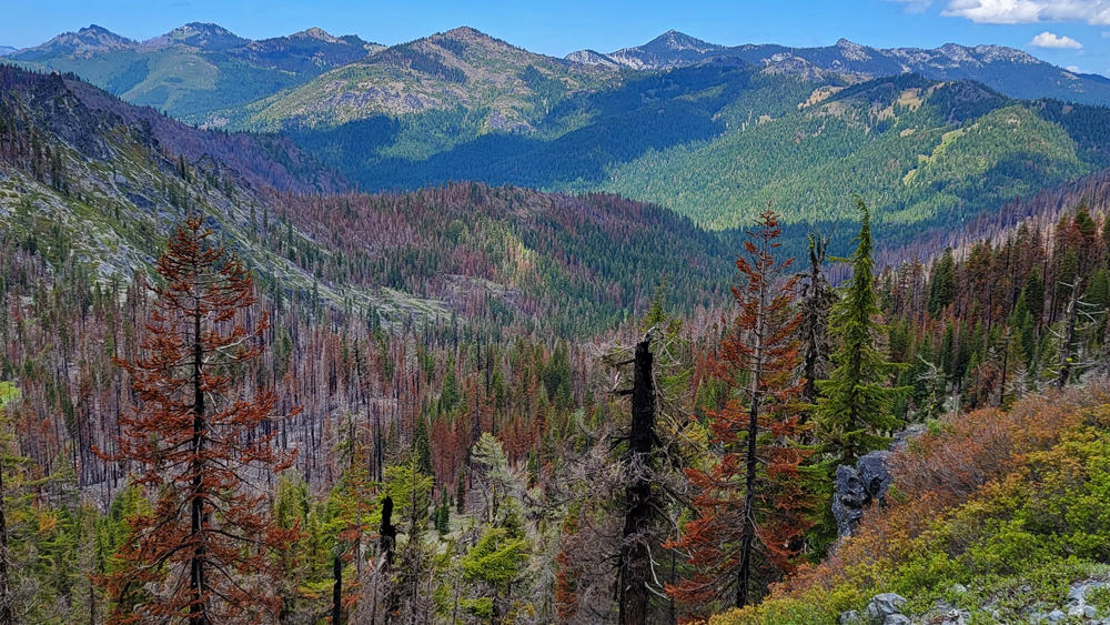
Damage from the 2021 River Complex Fire is evident in the Trail Gulch Lake valley. The mountains to the north of Carter Meadows, including the Russian Wilderness, escaped the wildfire.
Trail Gulch Lake/Long Gulch Lake Loop Key Data
Distance: 9.8-mile loop; you can also do shorter hikes directly to either of the lakes, with Trail Gulch Lake the easiest
Difficulty: Moderate to strenuous for the entire loop
Type: longer day hike, or an excellent one- to two-night relatively easy backpacking trip
Elevation gain: 2100 feet
High point: 7400 feet
Season: mid-June to mid-October, depending on snow
Contact: Klamath National Forest, Salmon/Scott River Ranger District
Maps: Green Trails Maps Trinity Alps Wilderness
Permits: required only for overnight trips
Notes: Dogs allowed. Wilderness permit required for overnight stays: contact the Salmon/Scott River Ranger District for details. Cattle may be present, especially later in summer
This Hike Is Featured in One of My Books…
Best Day Hiking Trails in Upper California
Mycompact guidebook has the 125 best day hikes:
Mount Shasta and nearby
Lassen Volcanic National Park
Trinity Alps and Marble Mountains
Redding area
Whiskeytown and Shasta Lakes
Includes trailhead directions and detailed maps and trail descriptions
Buy it:on Amazon | on Bookshop.org Often available at bookstoresand outdoor stores (call first!)
Long Gulch Lake Trailhead Directions
Reach Callahan on Highway 3. Callahan is 39.2 miles from the junction of Highway 3 and I-5 in Yreka, 61.8 miles from Weaverville, and 26.7 miles from Gazelle near I-5 via Gazelle-Callahan Road. Reach Carter Summit (actually a saddle) at 12.0 miles and then turn left at 12.7 miles onto dirt Forest Road 39N08 signed for Carter Meadows. At 2.0 miles see the Trail Gulch Lake trailhead on the left, and then proceed 0.8 mile farther to the Lung Gulch Lake trailhead, the start of the loop.
Trail map of the Trail Gulch Lake – Long Gulch Lake loop hike. NOTE: THE NAMES OF THE TWO LAKES ARE REVERSED ON THE MAP! (Courtesy Caltopo)
Starting on Forest Road 39N08
I do this hike as a clockwise loop. I started at the Long Gulch Lake trailhead and got the 0.8 mile and 300 feet elevation gain on Forest Road 39N08 out of the way immediately. The River Complex Fire frequently burned right to the south edge of Forest Road 39N08, but burned very little beyond.
Explore the Wild and Rugged Trinity Alps With This New Map!
The alpine lakes and jagged peaks of the Trinity Alps Wilderness rival the scenery of the High Sierra, without the crowds. This new highly detailed map is perfect for your next backpacking trip or day hike:
Canyon Creek Lakes, Caribou Lake, and all the main destinations
Trails with more solitude in more remote parts of the wilderness
Often available at outdoor stores and bookstores (call first!)
The Hike to Trail Gulch Lake
From the Trail Gulch Lake trailhead it’s 2.1 miles and 875 feet of elevation gain to the lake.
Trail Gulch Creek meadow: the meadow is still green and beautiful, with some trees burned on its edges. You can see that the River Complex Fire burned fairly hot on the east slope.The Trail Gulch Creek meadow is lush, with standing water at its northern edge well into summer.
Above the meadow, the trail climbs more steeply up to the junction with the side trail that leads to the Trail Gulch Lake. There’s a beautiful northward view down the drainage, with the Russian Wilderness beyond.
Trail Gulch Drainage: River Complex Fire damage is evident to the mouth of Trail Gulch Creek, but the mountains beyond, including the Russian Wilderness, are untouched.
Trail Gulch Lake
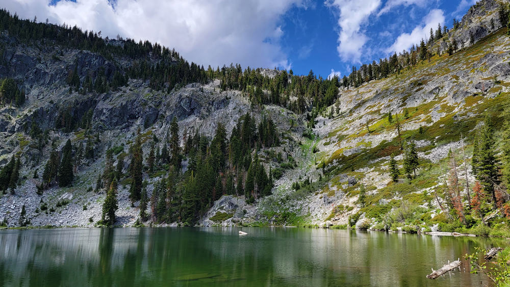
There is some River Complex Fire damage along the north shore and east shore of Trail Gulch Lake, but overall this is still a fantastic destination and one of the easiest backpacking trips in the Trinity Alps.
Trail Gulch Lake: River Complex Fire damage near the east shore.The south shore of Trail Gulch Lake is in beautiful shape. I once swam across the lake to that side, but it was too cool to swim on this day.The southwest shore of Trail Gulch Lake
Lots of River Complex Fire Damage…
is evident upon returning to the trail junction and then doing the steep hike through the red fir forest up to the ridge.
The River Complex Fire burned hot here in 2021, completely burning the trees and the ground cover. Those are dead needles from the trees.And some trees in the forest did survive the wildfire.
After the steep climb, I was happy to reach the ridge, close to the high point of the loop hike.
Extent of the 2021 River Complex Fire damage to the Trail Gulch Lake drainage in the northern Trinity Alps
River Complex Fire Damage on the South Side the Ridge Connecting the Trail Gulch Lake and Long Gulch Lake Valleys
The trail runs west by southwest, primarily through a red fir forest, to gently climb to a ridge overlooking Long Gulch Lake. Gaps in the trees allow good southerly views of the extensive Coffee Creek drainage.
At the beginning of this stretch are two trail forks within about 30 feet of each other: North Fork Coffee Creek Trail (sign burned), and the Steveale Trail (sign intact). I’ve never hiked either of these, but the River Complex Fire burned substantial portions of their routes.
Looking southeast: substantial 2021 River Complex Fire damage in the eastern tributaries of Coffee CreekThe River Complex Fire burned these red firs and the ground cover.North Fork Coffee Creek and surrounding slopes and mountainsView southwest toward the heart of the Coffee Creek watershedRidge between Trail Gulch Lake and Long Gulch Lake: the path has many areas only partly burned by the 2021 wildfire.
Long Gulch Lake
Long Gulch Lake and its valley fared a bit better than the Trail Gulch Lake drainage, although I did see substantial wildfire burn evidence on the hike from the lake to the Long Gulch Lake trailhead.
Long Gulch Lake Trail: River Complex Fire effects. I believe the ridge on the west was mostly rocky with little vegetation prior to the fire.Long Gulch Lake itself survived the River Complex Fire in pretty good shape.Long Gulch Lake: still beautiful and with the steep south slope lookin’ goodLong Gulch Lake: view southeast. Still a Trinity Alps treasure…
My Youtube Video of the Trail Gulch Lake/Long Gulch Lake Loop Hike…
Lots of Great Dispersed Camping Sites in/near Carter Meadows
Camp for Free in California National Forests
California’s national forests and BLM lands have thousands of miles of dirt roads with lots of spots for dispersed camping (boondocking). My book provides all the info you need to get started (but is not a guide to specific sites):
Like just about every other website on the planet, NCHT uses cookies. Continuing to use the site means you're OK with that.Cookie settingsACCEPT
Privacy & Cookies Policy
Privacy Overview
This website uses cookies to improve your experience while you navigate through the website. Out of these cookies, the cookies that are categorized as necessary are stored on your browser as they are essential for the working of basic functionalities of the website. We also use third-party cookies that help us analyze and understand how you use this website. These cookies will be stored in your browser only with your consent. You also have the option to opt-out of these cookies. But opting out of some of these cookies may have an effect on your browsing experience.
Necessary cookies are absolutely essential for the website to function properly. This category only includes cookies that ensures basic functionalities and security features of the website. These cookies do not store any personal information.
Any cookies that may not be particularly necessary for the website to function and is used specifically to collect user personal data via analytics, ads, other embedded contents are termed as non-necessary cookies. It is mandatory to procure user consent prior to running these cookies on your website.

 My compact guidebook has the 125 best day hikes:


 California’s national forests and BLM lands have thousands of miles of dirt roads with lots of spots for dispersed camping (boondocking). My book provides all the info you need to get started (but is not a guide to specific sites):


%27%20fill-opacity%3D%27.5%27%3E%3Cellipse%20fill%3D%22%23f9f4ff%22%20fill-opacity%3D%22.5%22%20rx%3D%221%22%20ry%3D%221%22%20transform%3D%22matrix(91.31382%2066.02258%20-35.05562%2048.48435%2046.5%20157.6)%22%2F%3E%3Cpath%20fill%3D%22%23b8c768%22%20fill-opacity%3D%22.5%22%20d%3D%22M238.3%20231.9L140-24.1l129.1-49.6%2098.3%20256z%22%2F%3E%3Cellipse%20fill%3D%22%23b4aece%22%20fill-opacity%3D%22.5%22%20rx%3D%221%22%20ry%3D%221%22%20transform%3D%22rotate(-113.2%20136.3%2016.5)%20scale(262.7941%2029.81633)%22%2F%3E%3Cellipse%20fill%3D%22%23d3e187%22%20fill-opacity%3D%22.5%22%20rx%3D%221%22%20ry%3D%221%22%20transform%3D%22rotate(49%20-28.4%2084)%20scale(111.55642%2038.65434)%22%2F%3E%3C%2Fg%3E%3C%2Fsvg%3E "Burney Falls January 2025 Hiking Trails Closure Details")

%22%20transform%3D%22translate(.6%20.6)%20scale(1.17188)%22%20fill-opacity%3D%22.5%22%3E%3Cellipse%20fill%3D%22%23e2d5bf%22%20rx%3D%221%22%20ry%3D%221%22%20transform%3D%22rotate(-155%20112%2050)%20scale(117.46636%2046.71765)%22%2F%3E%3Cellipse%20fill%3D%22%23004cc3%22%20rx%3D%221%22%20ry%3D%221%22%20transform%3D%22matrix(252.06102%20-13.65114%201.97334%2036.43674%20139.2%209.9)%22%2F%3E%3Cellipse%20fill%3D%22%23261d19%22%20rx%3D%221%22%20ry%3D%221%22%20transform%3D%22matrix(-42.68706%2017.85638%20-11.82445%20-28.26725%20231.4%2055.8)%22%2F%3E%3Cellipse%20fill%3D%22%233674e2%22%20cx%3D%229%22%20cy%3D%2212%22%20rx%3D%2265%22%20ry%3D%2265%22%2F%3E%3C%2Fg%3E%3C%2Fsvg%3E "2024 Free Entrance Days at Northern California National Parks and Monuments")


Leave a Reply