Mount Shasta Area | Lassen Area | Trinity Alps | Shasta-Trinity NF | Klamath NF | Redwood Coast | Wine Country | Bay Area | Sierra Nevada | Hiking Advice
This easy hiking trail takes you to the granite heights of the Sierra Nevada, Lake Margaret in Eldorado National Forest just off Highway 88. It makes a great day hike or an overnight backpacking trip for the whole family.
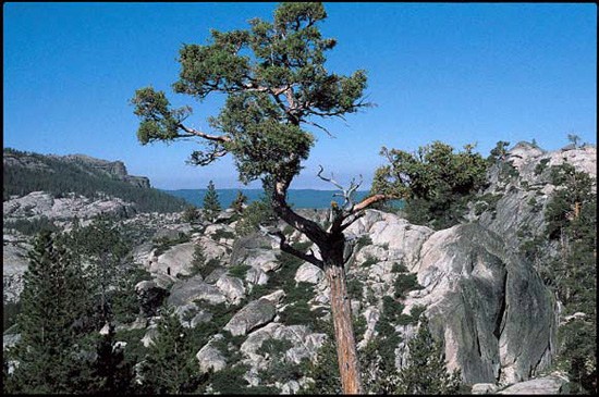
Near Lake Margaret in Sierra Nevada’s Eldorado National Forest (Photo by Marc Soares)
Often available at Barnes & Noble, REI, and other quality bookstoresand outdoor stores (call first!)
Lake Margaret Trail Key Information
Length: 5 miles round-trip
Hiking time: 3 hours or overnight
|High point: 7,750 feet
Total elevation gain: 550 feet
Difficulty: easy
Season: early July through late October
Water: available from streams and Lake Margaret (purify first)
Maps: USGS 7.5′ Caples Lake, USFS Mokelumne Wilderness
Information: Amador Ranger Station, Eldorado National Forest
This hike’s gentle trail takes you near the lush green banks of Caples Creek and past huge slabs of granite to Lake Margaret, where you can picnic, swim, and enjoy the mountain scenery. It’s a good outing for those wanting a lot of nature for only a little effort. Feel free to contact the Amador Ranger Station (209-295-4251) for more information about campfire permits and fire restrictions (stove use recommended). During summer, you can also call the Carson Pass Information Station (209-258-8606).
Directions to the Trailhead
Take the turnoff on the north side of Highway 88 about 0.2 mile west of the Caples Lake Dam (the trailhead for Hike 3: Emigrant Lake) and 0.5 mile east of the turnoff for the Kirkwood Ski Area. Follow the short road 150 yards to its end.
Hiking the Trail to Lake Margaret
The signed trail begins at the west end of the parking area, just north of the road. Descend through a lodgepole pine and red fir forest at a moderate pitch, and then cross a seasonal creek at 0.2 mile. The trail heads east briefly; look straight ahead for glimpses of the high mountain ridge just north of Caples Lake.
The path briefly parallels and then crosses another seasonal creek. A good picnic spot lies just to the left of the trail as you near the banks of Caples Creek at 0.6 mile, where there’s green grass and the creek’s clear waters are deep enough for wading.
The trail quickly reaches the creek itself and crosses it on a fallen tree. You soon begin a gentle climb through a gully bordered by huge granite hillocks. After the path levels, it skirts a small, lodgepole pine- and willow-ringed pond on the left at 1.2 miles and then crosses some granite.
A much larger pond, surrounded by lodgepole pine and red fir, awaits on the right at 1.6 miles. You soon cross a stream, pass through a large thicket of mountain alder, and then note that western white pine has joined the forest cover.
Quaking aspen, with their tremulous green leaves and bright white bark, begin to border the trail at 2.2 miles; they accompany you for 300 yards to a stream, which you cross on a log. You now begin the final ascent to your destination, following rock ducks (cairns) up the gently sloping granite.
After the brief climb, you reach the deep waters of Lake Margaret. Numerous granite slabs stretch from high above to far below the lake’s surface. You’ll find many places to swim, either near the shore or out to some of the small granite islands that dot the lake’s surface. Campers will find two sites along the east shore and two more near the west shore.
Topographic map of the Lake Margaret Trail, Amador Ranger District, Eldorado National Forest. (Courtesy of Caltopo.com)
Your Take
Have you been to Lake Margaret? What did you think?
Camp for Free in California National Forests
California’s national forests and BLM lands have thousands of miles of dirt roads with lots of spots for dispersed camping (boondocking). My book provides all the info you need to get started (but is not a guide to specific sites):
Would you be interested in completing a hiking interview via email? Your interview will be posted in the “Hiking Interviews” category on TracksAndTrails.ca and any of your site links that you mention in the interview will be made live.
Here are the interview questions that you or any hiker who would like to can email back to me.
How and where were you introduced to the outdoors?
What has been your favourite hiking trail or outdoor area?
Please share an outdoor story related to one of the above areas.
Have you ever been lost in the wilderness? If so please describe this adventure and any lessons learned.
Can you share any unique encounters with wild animals?
If not previously mentioned, have you ever completed a thru-hike or multi-day backpacking trip and what nuggets of wisdom did you glean from it?
What is your favourite outdoor website?
What is your favourite outdoor hiking gear store?
Thank you!
PS – I really appreciate the quality hiking trail information on your site and have added a couple of your posts to tracksandtrails.ca with links back to you.
I am looking for material or a book that us more specific to hiking trails/day trails for El Dorado National Forest, off Hwy 50 area between Placerille & Tahoe, Hwy 88, Mormon Immirgrant Trail, Desolation Wildness, Amador County area, Grizzly Flats.
2023–The Forest Service, El Dorado County, CalFire and local cabin residents are concerned about the danger of hiking in areas burned in the CalDor fire (2021; highway 50 and the region South to Silver Lake on highway88). Standing trees look secure, but may have burned out root systems, and can fall without anger. We are told that root systems can burn through the winter, or may have created unexposed pits which represent additional danger for hikers. Have a care where you hike and camp in fire areas.
Like just about every other website on the planet, NCHT uses cookies. Continuing to use the site means you're OK with that.Cookie settingsACCEPT
Privacy & Cookies Policy
Privacy Overview
This website uses cookies to improve your experience while you navigate through the website. Out of these cookies, the cookies that are categorized as necessary are stored on your browser as they are essential for the working of basic functionalities of the website. We also use third-party cookies that help us analyze and understand how you use this website. These cookies will be stored in your browser only with your consent. You also have the option to opt-out of these cookies. But opting out of some of these cookies may have an effect on your browsing experience.
Necessary cookies are absolutely essential for the website to function properly. This category only includes cookies that ensures basic functionalities and security features of the website. These cookies do not store any personal information.
Any cookies that may not be particularly necessary for the website to function and is used specifically to collect user personal data via analytics, ads, other embedded contents are termed as non-necessary cookies. It is mandatory to procure user consent prior to running these cookies on your website.

 The all-color fourth edition features the best trails:
 California’s national forests and BLM lands have thousands of miles of dirt roads with lots of spots for dispersed camping (boondocking). My book provides all the info you need to get started (but is not a guide to specific sites):
%22%20transform%3D%22translate(.6%20.6)%20scale(1.17188)%22%20fill-opacity%3D%22.5%22%3E%3Cellipse%20fill%3D%22%23e2d5bf%22%20rx%3D%221%22%20ry%3D%221%22%20transform%3D%22rotate(-155%20112%2050)%20scale(117.46636%2046.71765)%22%2F%3E%3Cellipse%20fill%3D%22%23004cc3%22%20rx%3D%221%22%20ry%3D%221%22%20transform%3D%22matrix(252.06102%20-13.65114%201.97334%2036.43674%20139.2%209.9)%22%2F%3E%3Cellipse%20fill%3D%22%23261d19%22%20rx%3D%221%22%20ry%3D%221%22%20transform%3D%22matrix(-42.68706%2017.85638%20-11.82445%20-28.26725%20231.4%2055.8)%22%2F%3E%3Cellipse%20fill%3D%22%233674e2%22%20cx%3D%229%22%20cy%3D%2212%22%20rx%3D%2265%22%20ry%3D%2265%22%2F%3E%3C%2Fg%3E%3C%2Fsvg%3E "2024 Free Entrance Days at Northern California National Parks and Monuments")
%22%20transform%3D%22translate(.6%20.6)%20scale(1.17188)%22%20fill-opacity%3D%22.5%22%3E%3Cellipse%20fill%3D%22%23316256%22%20cx%3D%22235%22%20cy%3D%2248%22%20rx%3D%2256%22%20ry%3D%2268%22%2F%3E%3Cellipse%20fill%3D%22%23e1dee4%22%20rx%3D%221%22%20ry%3D%221%22%20transform%3D%22matrix(134.62378%2069.95549%20-12.91898%2024.86156%20200.9%20146)%22%2F%3E%3Cellipse%20fill%3D%22%23805d23%22%20rx%3D%221%22%20ry%3D%221%22%20transform%3D%22rotate(-6.1%201021.4%20-51.4)%20scale(31.10221%2093.66742)%22%2F%3E%3Cellipse%20fill%3D%22%23dedbe1%22%20cx%3D%22104%22%20cy%3D%225%22%20rx%3D%2272%22%20ry%3D%2223%22%2F%3E%3C%2Fg%3E%3C%2Fsvg%3E "Give the Gift of Hiking and Camping Books This Year!")


Would you be interested in completing a hiking interview via email? Your interview will be posted in the “Hiking Interviews” category on TracksAndTrails.ca and any of your site links that you mention in the interview will be made live.
Here are the interview questions that you or any hiker who would like to can email back to me.
How and where were you introduced to the outdoors?
What has been your favourite hiking trail or outdoor area?
Please share an outdoor story related to one of the above areas.
Have you ever been lost in the wilderness? If so please describe this adventure and any lessons learned.
Can you share any unique encounters with wild animals?
If not previously mentioned, have you ever completed a thru-hike or multi-day backpacking trip and what nuggets of wisdom did you glean from it?
What is your favourite outdoor website?
What is your favourite outdoor hiking gear store?
Thank you!
PS – I really appreciate the quality hiking trail information on your site and have added a couple of your posts to tracksandtrails.ca with links back to you.
I am looking for material or a book that us more specific to hiking trails/day trails for El Dorado National Forest, off Hwy 50 area between Placerille & Tahoe, Hwy 88, Mormon Immirgrant Trail, Desolation Wildness, Amador County area, Grizzly Flats.
2023–The Forest Service, El Dorado County, CalFire and local cabin residents are concerned about the danger of hiking in areas burned in the CalDor fire (2021; highway 50 and the region South to Silver Lake on highway88). Standing trees look secure, but may have burned out root systems, and can fall without anger. We are told that root systems can burn through the winter, or may have created unexposed pits which represent additional danger for hikers. Have a care where you hike and camp in fire areas.